IMAGES TAKEN NEAR TO
Elsham, BRIGG, DN20 0LU
Introduction
This page details the photographs taken nearby to DN20 0LU by members of the Geograph project.
The Geograph project started in 2005 with the aim of publishing, organising and preserving representative images for every square kilometre of Great Britain, Ireland and the Isle of Man.

There are currently over 7.5m images from over14,400 individuals and you can help contribute to the project by visiting https://www.geograph.org.uk
Image Map
Images are licensed for reuse under creativecommons.org/licenses/by-sa/2.0
Notes
- Clicking on the map will re-center to the selected point.
- The higher the marker number, the further away the image location is from the centre of the postcode.
Image Listing (11 Images Found)
Images are licensed for reuse under creativecommons.org/licenses/by-sa/2.0
Image
Details
Distance
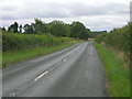
1
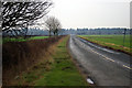
The Elsham Road
Photo taken nr. Elsham House looking southwest towards the junction with the B1206.
Image: © David Wright
Taken: 23 Jan 2006
0.04 miles
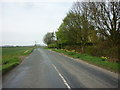
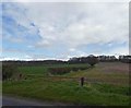
4
Bend in the B1204
South of Worlaby.
Image: © J.Hannan-Briggs
Taken: 11 Sep 2016
0.06 miles
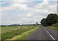
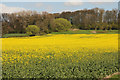
5
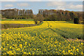
Elsham Hill
Oilseed rape on the escarpment of Elsham Hill near Elsham House, with the hedge forming the parish boundary between Elsham and Worlaby
Image: © Richard Croft
Taken: 15 Apr 2014
0.08 miles
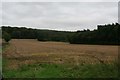
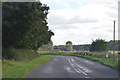
8
Farmland and Elsham May Bank Drain next to Elsham Road, Worlaby
Image: © Chris
Taken: 1 Oct 2017
0.15 miles
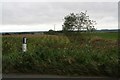
10
Elsham Hill
Oilseed rape on the Worlaby side of the parish boundary http://www.geograph.org.uk/photo/3935273 on Elsham Hill
Image: © Richard Croft
Taken: 15 Apr 2014
0.18 miles