IMAGES TAKEN NEAR TO
Hurds Farm, BRIGG, DN20 0FE
Introduction
This page details the photographs taken nearby to Hurds Farm, DN20 0FE by members of the Geograph project.
The Geograph project started in 2005 with the aim of publishing, organising and preserving representative images for every square kilometre of Great Britain, Ireland and the Isle of Man.

There are currently over 7.5m images from over14,400 individuals and you can help contribute to the project by visiting https://www.geograph.org.uk
Image Map
Images are licensed for reuse under creativecommons.org/licenses/by-sa/2.0
Notes
- Clicking on the map will re-center to the selected point.
- The higher the marker number, the further away the image location is from the centre of the postcode.
Image Listing (78 Images Found)
Images are licensed for reuse under creativecommons.org/licenses/by-sa/2.0
Image
Details
Distance
2
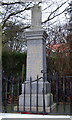
Worlaby War Memorial
Worlaby War Memorial (1914-1918)
Image: © David Wright
Taken: 23 Jan 2006
0.05 miles
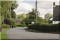
3
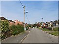
Worlaby
Worlaby, North Lincolnshire. The road going left is Main Street and to the right is Top Road.
Image: © David Wright
Taken: 23 Jan 2006
0.05 miles
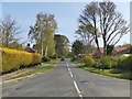
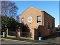
4
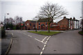
Worlaby: Top Road
House at the junction with The Hill
Image: © Paul Harrop
Taken: 19 Mar 2020
0.08 miles
8
War memorial, Worlaby
A very quiet village. Perhaps they have all gone to Spain for the winter?
Image: © David Brown
Taken: 15 Dec 2022
0.10 miles
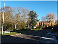
10
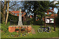
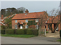
Worlaby
War Memorial and noticeboard on Top Road in Worlaby
Image: © Richard Croft
Taken: 15 Apr 2014
0.10 miles