IMAGES TAKEN NEAR TO
Thornton Road, BARROW-UPON-HUMBER, DN19 7LW
Introduction
This page details the photographs taken nearby to Thornton Road, DN19 7LW by members of the Geograph project.
The Geograph project started in 2005 with the aim of publishing, organising and preserving representative images for every square kilometre of Great Britain, Ireland and the Isle of Man.

There are currently over 7.5m images from over14,400 individuals and you can help contribute to the project by visiting https://www.geograph.org.uk
Image Map
Images are licensed for reuse under creativecommons.org/licenses/by-sa/2.0
Notes
- Clicking on the map will re-center to the selected point.
- The higher the marker number, the further away the image location is from the centre of the postcode.
Image Listing (8 Images Found)
Images are licensed for reuse under creativecommons.org/licenses/by-sa/2.0
Image
Details
Distance

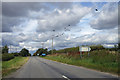
2
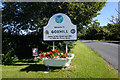
Goxhill home of the American 8th, 345 Air Force Base
Image: © Ian S
Taken: 19 Jul 2020
0.05 miles
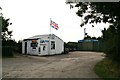
5
A Relic of Goxhill Airfield
Ruinous war-time building off Thornton Road.
Image: © David Wright
Taken: 1 Sep 2007
0.19 miles
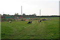
6
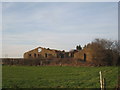
Decayed buildings
Probably connected with the wartime airbase in Goxhill.
Image: © Jonathan Thacker
Taken: 11 Mar 2012
0.21 miles
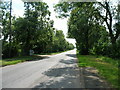
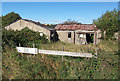
8
Thornton Road, Goxhill
The birds on the electricity cables are Crows.
Image: © David Wright
Taken: 30 Aug 2007
0.23 miles