IMAGES TAKEN NEAR TO
Thornton Road, BARROW-UPON-HUMBER, DN19 7LR
Introduction
This page details the photographs taken nearby to Thornton Road, DN19 7LR by members of the Geograph project.
The Geograph project started in 2005 with the aim of publishing, organising and preserving representative images for every square kilometre of Great Britain, Ireland and the Isle of Man.

There are currently over 7.5m images from over14,400 individuals and you can help contribute to the project by visiting https://www.geograph.org.uk
Image Map
Images are licensed for reuse under creativecommons.org/licenses/by-sa/2.0
Notes
- Clicking on the map will re-center to the selected point.
- The higher the marker number, the further away the image location is from the centre of the postcode.
Image Listing (13 Images Found)
Images are licensed for reuse under creativecommons.org/licenses/by-sa/2.0
Image
Details
Distance
1
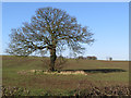
The Hallands, near Goxhill
Tree in a field seen from Thornton Road
Image: © Paul Harrop
Taken: 18 Feb 2016
0.08 miles
3
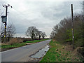
Anglian Water Pumping Station
Pumping station on Thornton Road.
Image: © David Wright
Taken: 21 Jul 2010
0.12 miles
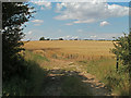
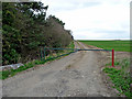
7
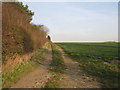
Track off Thornton Road
Provides field access to land to the north of the Grange.
Image: © Jonathan Thacker
Taken: 11 Mar 2012
0.14 miles
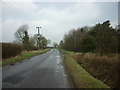
8
Both sides of the hedge
Thornton Road to the right.
Image: © Jonathan Thacker
Taken: 11 Mar 2012
0.14 miles
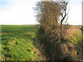
10
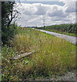
Ditch on Thornton Road
Complete re-growth of vegetation since my last visit fifteen months ago Image
Image: © David Wright
Taken: 21 Jul 2010
0.16 miles