IMAGES TAKEN NEAR TO
Ferry Road, BARROW-UPON-HUMBER, DN19 7LD
Introduction
This page details the photographs taken nearby to Ferry Road, DN19 7LD by members of the Geograph project.
The Geograph project started in 2005 with the aim of publishing, organising and preserving representative images for every square kilometre of Great Britain, Ireland and the Isle of Man.

There are currently over 7.5m images from over14,400 individuals and you can help contribute to the project by visiting https://www.geograph.org.uk
Image Map
Images are licensed for reuse under creativecommons.org/licenses/by-sa/2.0
Notes
- Clicking on the map will re-center to the selected point.
- The higher the marker number, the further away the image location is from the centre of the postcode.
Image Listing (42 Images Found)
Images are licensed for reuse under creativecommons.org/licenses/by-sa/2.0
Image
Details
Distance
1
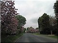
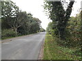
Pink May blossom lined Ferry Road, Goxhill
Image: © Steve Fareham
Taken: 10 May 2013
0.04 miles
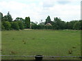
3
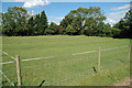
Ridge & Furrow Field Pattern near Ferry Road
For more information on Ridge & Furrow see Wikipedia http://en.wikipedia.org/wiki/Ridge_and_furrow
Image: © David Wright
Taken: 1 Aug 2008
0.07 miles
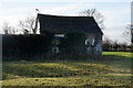
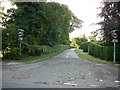
4
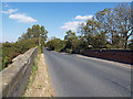
Ferry Road, Goxhill
Photo taken from the bridge over the New Holland - Goxhill rail line.
Image: © David Wright
Taken: 16 Sep 2007
0.07 miles
5
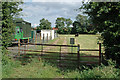
Public Footpath towards Ferry Road
A rather awkward type of stile at this gate and a very noisy Alsatian guard dog at the stables on the left.
Image: © David Wright
Taken: 1 Aug 2008
0.08 miles