IMAGES TAKEN NEAR TO
West Marsh Lane, BARROW-UPON-HUMBER, DN19 7HA
Introduction
This page details the photographs taken nearby to West Marsh Lane, DN19 7HA by members of the Geograph project.
The Geograph project started in 2005 with the aim of publishing, organising and preserving representative images for every square kilometre of Great Britain, Ireland and the Isle of Man.

There are currently over 7.5m images from over14,400 individuals and you can help contribute to the project by visiting https://www.geograph.org.uk
Image Map
Images are licensed for reuse under creativecommons.org/licenses/by-sa/2.0
Notes
- Clicking on the map will re-center to the selected point.
- The higher the marker number, the further away the image location is from the centre of the postcode.
Image Listing (44 Images Found)
Images are licensed for reuse under creativecommons.org/licenses/by-sa/2.0
Image
Details
Distance
1
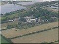
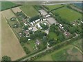
Anti-Aircraft Battery site west of Barrow Haven: aerial 2022 (1)
See: https://historicengland.org.uk/listing/the-list/list-entry/1020024?section=official-list-entry
Image: © Simon Tomson
Taken: 15 Jun 2022
0.11 miles
2
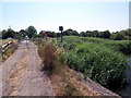
West Marsh Lane Crossing
Picture taken from the access track to Humber Water Ski Club looking South.
Image: © David Wright
Taken: 19 Jul 2006
0.13 miles
3
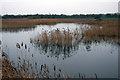
Reedbed in December
Photo taken from West Marsh Lane near the level crossing. For a summer view see Image
Image: © David Wright
Taken: 26 Dec 2006
0.13 miles
4
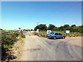
West Marsh Lane Level Crossing
This level crossing is at the northern end of West Marsh Lane. The track across the railway is the access road for the Humber Bridge Water Ski Club. The turning to the right is a private road going to the Sandtoft Tile Works at Barrow Haven.
Image: © David Wright
Taken: 19 Jul 2006
0.13 miles
5
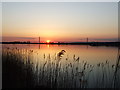
Barrow Haven Claypit
Barrow Haven Claypit, Humber Bridge in background.
Image: © David Hebb
Taken: 11 Apr 2007
0.13 miles
6
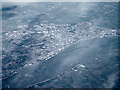
Kingston Upon Hull from the air
Part of the Humber bridge is visible in the lower left corner. Viewed from a flight from Glasgow to Dusselforf.
Image: © Thomas Nugent
Taken: 10 Feb 2014
0.13 miles
7
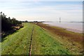
Humber Bank
Looking West along the Humber bank towards Barton and the bridge.
Image: © David Wright
Taken: 12 Sep 2005
0.13 miles
8
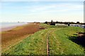
Humber Bank
View East along the Humber Bank towards New Holland. The caravans on the right belong to the Water Ski Club.
Image: © David Wright
Taken: 12 Sep 2005
0.13 miles
9
Anti-Aircraft Battery site west of Barrow Haven: aerial 2022 (2)
See: https://historicengland.org.uk/listing/the-list/list-entry/1020024?section=official-list-entry
Image: © Simon Tomson
Taken: 15 Jun 2022
0.14 miles
10
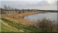
Just two more lakes beside the Humber
Image: © Chris Morgan
Taken: 16 Mar 2015
0.14 miles