IMAGES TAKEN NEAR TO
Saddle Close, BARROW-UPON-HUMBER, DN19 7GB
Introduction
This page details the photographs taken nearby to Saddle Close, DN19 7GB by members of the Geograph project.
The Geograph project started in 2005 with the aim of publishing, organising and preserving representative images for every square kilometre of Great Britain, Ireland and the Isle of Man.

There are currently over 7.5m images from over14,400 individuals and you can help contribute to the project by visiting https://www.geograph.org.uk
Image Map
Images are licensed for reuse under creativecommons.org/licenses/by-sa/2.0
Notes
- Clicking on the map will re-center to the selected point.
- The higher the marker number, the further away the image location is from the centre of the postcode.
Image Listing (34 Images Found)
Images are licensed for reuse under creativecommons.org/licenses/by-sa/2.0
Image
Details
Distance
2
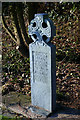
Goxhill Cemetery - Monument to William & Minnie Raby
Celtic cross monument to William & Minnie Raby in Goxhill cemetery, North Lincolnshire (by Philip Pape ?)
Image: © David Wright
Taken: 28 Jan 2006
0.12 miles
3

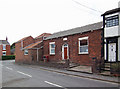
The Old Wesleyan School, Thorn Lane, Goxhill
This building is dated 1855. http://www.bartoncircuit.btinternet.co.uk/goxhist.htm states: "It was in 1855 that the local Wesleyans started their largest undertaking which was the building of a Wesleyan Day School. There was quite a lot of opposition for this school in the village but the Schoolrooms, masters house and the playgrounds were finished by the end of that year. The total cost of the undertaking amounted to £866. About half of this cost came in the form of education grants and the rest had to be found locally. The land used for the school was formerly owned by Charles Burkinshaw and was purchased at a cost of £90. This was a reasonable price for some 1078square yards."
Image: © David Wright
Taken: 15 Jul 2008
0.15 miles
4
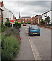
Chapel Street, Goxhill
Photo taken looking towards Howe Lane.
Image: © David Wright
Taken: 24 Jun 2010
0.15 miles
5
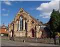
Goxhill Methodist Church
This church is situated on Chapel Lane and above the windows the front eave says "Primitive 1891 Methodist". Not mentioned in Pevsner but in my opinion nicely executed. Still in use and well maintained. For information on the history of Methodism in Goxhill see http://www.bartoncircuit.btinternet.co.uk/goxhist.htm
Image: © David Wright
Taken: 16 Sep 2007
0.15 miles
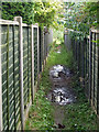
6
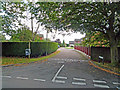
Trinity Close, Goxhill
This is the start of the public footpath which crosses the old Goxhill airfield. The path runs up Trinity Close and then passes between the houses just to the left of the conifer in the centre of the picture.
Image: © David Wright
Taken: 23 Sep 2008
0.16 miles
7
Wesleyan Methodist Sabbath School, Goxhill
Wesleyan Methodist Sunday School on Chapel Street built in 1840. Still in use as I noticed their wheelie bins are marked "Church Room". For another Wesleyan Methodist Sunday School in nearby Barrow Upon Humber see Image
Image: © David Wright
Taken: 15 Sep 2007
0.16 miles
8
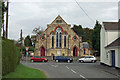
Goxhill Methodist Church
This church is situated on Chapel Lane and above the windows the front eave says "Primitive 1891 Methodist". Not mentioned in Pevsner but in my opinion nicely executed. Still in use and well maintained.
Image: © David Wright
Taken: 15 Sep 2007
0.16 miles
9
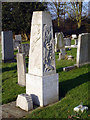
Mellers Monument - Goxhill Cemetery
Described in Pevsner "..by Philip Pape to Walter Mellars, 1935, a monolith with deeply carved expressionist scenes of the Creation.."
Image: © David Wright
Taken: 28 Jan 2006
0.16 miles
10
The Public Footpath to Chapel Field Road
At this point the path is passing between two houses on Trinity Close Image before entering a plantation of SRC Willow Image
Image: © David Wright
Taken: 23 Sep 2008
0.17 miles