IMAGES TAKEN NEAR TO
Mill Lane, BARTON-UPON-HUMBER, DN18 6JP
Introduction
This page details the photographs taken nearby to Mill Lane, DN18 6JP by members of the Geograph project.
The Geograph project started in 2005 with the aim of publishing, organising and preserving representative images for every square kilometre of Great Britain, Ireland and the Isle of Man.

There are currently over 7.5m images from over14,400 individuals and you can help contribute to the project by visiting https://www.geograph.org.uk
Image Map
Images are licensed for reuse under creativecommons.org/licenses/by-sa/2.0
Notes
- Clicking on the map will re-center to the selected point.
- The higher the marker number, the further away the image location is from the centre of the postcode.
Image Listing (70 Images Found)
Images are licensed for reuse under creativecommons.org/licenses/by-sa/2.0
Image
Details
Distance
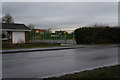
1
Tidal surge flooding on Old Warp Lane
South Ferriby.
Image: © Ian S
Taken: 16 Dec 2013
0.04 miles
4
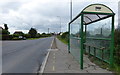
Bus shelter on Sluice Road, South Ferriby
Image: © Mat Fascione
Taken: 28 Aug 2016
0.07 miles
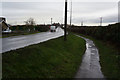
5

Sluice Road, South Ferriby, Lincolnshire
Ivy-clad 'Permissive Path HUMBER BANK' signpost, directing walkers to the New Cole Way.
Image: © Bernard Sharp
Taken: 30 Jun 2017
0.08 miles
8
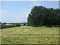
Field behind Manor Farm toward Cement Works
The cement works is at Ferriby Sluice. Open garden day at Manor Farm in aid of NGS
Image: © Martin Dawes
Taken: 11 Jun 2023
0.12 miles
9
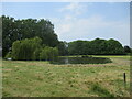
Pond in the field behind Manor Farm garden
Garden open for charity under National Garden Scheme. NGS.
Image: © Martin Dawes
Taken: 11 Jun 2023
0.12 miles