IMAGES TAKEN NEAR TO
Red Lane, BARTON-UPON-HUMBER, DN18 6JH
Introduction
This page details the photographs taken nearby to Red Lane, DN18 6JH by members of the Geograph project.
The Geograph project started in 2005 with the aim of publishing, organising and preserving representative images for every square kilometre of Great Britain, Ireland and the Isle of Man.

There are currently over 7.5m images from over14,400 individuals and you can help contribute to the project by visiting https://www.geograph.org.uk
Image Map (Loading...)


Getting Data...Please wait
Leaflet Map data © OpenStreetMap
Images are licensed for reuse under creativecommons.org/licenses/by-sa/2.0
Notes
- Clicking on the map will re-center to the selected point.
- The higher the marker number, the further away the image location is from the centre of the postcode.
Image Listing (260 Images Found)
Images are licensed for reuse under creativecommons.org/licenses/by-sa/2.0
Image
Details
Distance
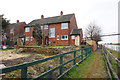
1

South Ferriby Marina
Sheds at South Ferriby Marina.
Image: © David Wright
Taken: 5 May 2007
0.02 miles
2

Amy Howson at South Ferriby Marina
The sloop, moored near South Ferriby, is often to be seen at various moorings around the Humber and its tributaries. For just one example see Image
Image: © Paul Harrop
Taken: 30 Sep 2015
0.02 miles
4
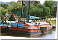
Humber Sloop "Amy Howson" at South Ferriby 2004
See: http://www.keelsandsloops.org.uk/humber-sloop-amy-howson.html
Developed from keels in the eighteenth century, the Humber sloop was designed to sail efficiently in the river’s shoal-ridden open estuarial waters, and to make coastal passages.
Sloops mainly handled bulk cargoes between the Humber ports, carrying farm produce from Lincolnshire, coal from the West Riding, bricks and tiles between both sides, cement and chalk stone from Barton and South Ferriby to Hull and transhipping phosphates back to the fertiliser works.
In summer the sea going trade would be to Louth, Saltfleet, the ports of the Wash and on south to the Thames, to the north trade would be to Bridlington, the Tyne and all ports between.
In 1981, the restored HKSPS sloop Amy Howson became the first sloop to sail the Humber in over thirty years.
Image: © Chris
Taken: Unknown
0.02 miles
7
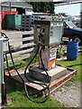
Marine Diesel Pump at South Ferriby Marina
I didn't check the price but I believe marine diesel is tax free.
Image: © David Wright
Taken: 21 Jul 2008
0.03 miles
8
South Ferriby Marina
Photo taken looking towards the sluice.
Image: © David Wright
Taken: 8 Sep 2008
0.03 miles
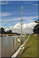
9

New River Ancholme
From Sluice Road, South Ferriby.
Image: © Ian S
Taken: 3 Aug 2022
0.03 miles
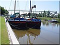
10
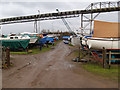
South Ferriby Marina
At this time of year all boats are removed from the water, using the crane in the background. This is because of the fluctuations in the level and flow on the Ancholme when the nearby sluice is used for flood control purposes.
Image: © David Wright
Taken: 24 Feb 2007
0.04 miles