IMAGES TAKEN NEAR TO
Farrishes Lane, BARTON-UPON-HUMBER, DN18 6HG
Introduction
This page details the photographs taken nearby to Farrishes Lane, DN18 6HG by members of the Geograph project.
The Geograph project started in 2005 with the aim of publishing, organising and preserving representative images for every square kilometre of Great Britain, Ireland and the Isle of Man.

There are currently over 7.5m images from over14,400 individuals and you can help contribute to the project by visiting https://www.geograph.org.uk
Image Map (Loading...)


Getting Data...Please wait
Leaflet Map data © OpenStreetMap
Images are licensed for reuse under creativecommons.org/licenses/by-sa/2.0
Notes
- Clicking on the map will re-center to the selected point.
- The higher the marker number, the further away the image location is from the centre of the postcode.
Image Listing (167 Images Found)
Images are licensed for reuse under creativecommons.org/licenses/by-sa/2.0
Image
Details
Distance
1
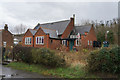
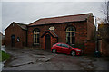
What looks like the old Village School
On Farrishes Lane, South Ferriby.
Image: © Ian S
Taken: 16 Dec 2013
0.01 miles
2
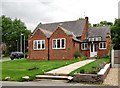
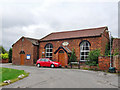
Farrishes Lane, South Ferriby, Lincolnshire
Post-1908, the Sunday School, later the church hall, now The Chapel School House, a private dwelling. Possibly linked with the Methodist Chapel opposite.
Image: © Bernard Sharp
Taken: 30 Jun 2017
0.01 miles
3
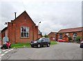
Farrishes Lane, South Ferriby, Lincolnshire
The Chapel School House, a private residence, formerly a Sunday School and Church Hall, built after 1908 and, right, the Methodist Chapel, 1839, now closed and for sale.
Image: © Bernard Sharp
Taken: 30 Jun 2017
0.01 miles
4
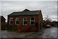
Methodist Chapel, South Ferriby
Built in 1839.
Image: © Ian S
Taken: 16 Dec 2013
0.01 miles
5
Methodist Chapel, South Ferriby
Built in 1839.
Image: © Ian S
Taken: 16 Dec 2013
0.02 miles
6
Farrishes Lane, South Ferriby, Lincolnshire
Methodist Chapel, date stone 1839. Now closed and for sale.
Image: © Bernard Sharp
Taken: 30 Jun 2017
0.02 miles
8
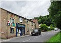
Sluice Road, South Ferriby, Lincolnshire
At the junction with Farrishes Lane, Post Office Stores. The gable end incorporates a stone at first-floor level inscribed: 'FARISHES LANE 1844' (sic), possibly a foundation stone.
Image: © Bernard Sharp
Taken: 30 Jun 2017
0.02 miles
9
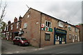
Post Office Stores, corner of High St. and Farrishes Lane, South Ferriby
Image: © Chris
Taken: 28 May 2016
0.03 miles
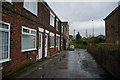
10
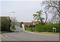
Sluice Road (from east end)
The main road through South Ferriby completes its fall down to the level of the Humber throuth Sluice Road.
Image: © George Robinson
Taken: 14 Apr 2007
0.03 miles