IMAGES TAKEN NEAR TO
Barrow Road, BARTON-UPON-HUMBER, DN18 6EY
Introduction
This page details the photographs taken nearby to Barrow Road, DN18 6EY by members of the Geograph project.
The Geograph project started in 2005 with the aim of publishing, organising and preserving representative images for every square kilometre of Great Britain, Ireland and the Isle of Man.

There are currently over 7.5m images from over14,400 individuals and you can help contribute to the project by visiting https://www.geograph.org.uk
Image Map (Loading...)


Getting Data...Please wait
Leaflet Map data © OpenStreetMap
Images are licensed for reuse under creativecommons.org/licenses/by-sa/2.0
Notes
- Clicking on the map will re-center to the selected point.
- The higher the marker number, the further away the image location is from the centre of the postcode.
Image Listing (52 Images Found)
Images are licensed for reuse under creativecommons.org/licenses/by-sa/2.0
Image
Details
Distance
3

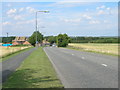
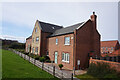
Sign for Barton Upon Humber
The runner is taking part in the Humber Bridge half marathon.
Image: © DS Pugh
Taken: 24 Jun 2018
0.07 miles
6

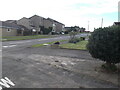
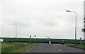
Falklands Way meets Barrow Road
Looking onto Barrow Road from Falklands Way.
Image: © DS Pugh
Taken: 24 Jun 2018
0.08 miles
9

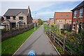
First runner heads onto Falklands Way
The runner is taking part in the Humber Bridge half marathon.
Image: © DS Pugh
Taken: 24 Jun 2018
0.08 miles
10
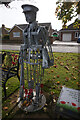
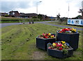
Battle of the Somme memorial
On Barrow Road, Burton-upon-Humber.
Image: © Ian S
Taken: 7 Oct 2020
0.09 miles