IMAGES TAKEN NEAR TO
Burnham, BARTON-UPON-HUMBER, DN18 6EF
Introduction
This page details the photographs taken nearby to DN18 6EF by members of the Geograph project.
The Geograph project started in 2005 with the aim of publishing, organising and preserving representative images for every square kilometre of Great Britain, Ireland and the Isle of Man.

There are currently over 7.5m images from over14,400 individuals and you can help contribute to the project by visiting https://www.geograph.org.uk
Image Map
Images are licensed for reuse under creativecommons.org/licenses/by-sa/2.0
Notes
- Clicking on the map will re-center to the selected point.
- The higher the marker number, the further away the image location is from the centre of the postcode.
Image Listing (10 Images Found)
Images are licensed for reuse under creativecommons.org/licenses/by-sa/2.0
Image
Details
Distance
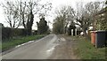
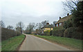
1
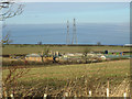
Looking towards Burnham Lodge
Photo taken from Race Lane.
Image: © David Wright
Taken: 7 Feb 2013
0.02 miles
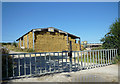
2
Near Burnham Lodge
A grain storage facility looms over the hedgerow
Image: © Neil Theasby
Taken: 30 Sep 2017
0.04 miles
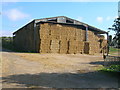
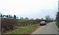
8
Near Burnham
Picture taken from the Thornton Curtis to Burnham road looking approx. East towards Burnham Lodge.
Image: © David Wright
Taken: 4 Feb 2006
0.14 miles
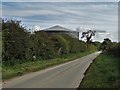
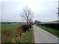
9
The Road to Burnham
Photo taken near Burnham Lodge.
Image: © David Wright
Taken: 4 Feb 2006
0.14 miles
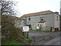
10
The Road to Burnham
Photo taken near Burnham Lodge. The white house on the hillside is not named on the 1:25000 OS map.
Image: © David Wright
Taken: 4 Feb 2006
0.19 miles