IMAGES TAKEN NEAR TO
Barrow Mere, BARTON-UPON-HUMBER, DN18 6DD
Introduction
This page details the photographs taken nearby to DN18 6DD by members of the Geograph project.
The Geograph project started in 2005 with the aim of publishing, organising and preserving representative images for every square kilometre of Great Britain, Ireland and the Isle of Man.

There are currently over 7.5m images from over14,400 individuals and you can help contribute to the project by visiting https://www.geograph.org.uk
Image Map (Loading...)


Getting Data...Please wait
Leaflet Map data © OpenStreetMap
Images are licensed for reuse under creativecommons.org/licenses/by-sa/2.0
Notes
- Clicking on the map will re-center to the selected point.
- The higher the marker number, the further away the image location is from the centre of the postcode.
Image Listing (19 Images Found)
Images are licensed for reuse under creativecommons.org/licenses/by-sa/2.0
Image
Details
Distance
1
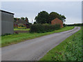
Lane at Barrow Mere
Leading south from the A1077 Barrow Road towards Beechgrove Farm
Image: © Paul Harrop
Taken: 5 Oct 2008
0.04 miles
2
Looking towards the Humber
View from the picnic area on the A1077 looking North towards the Humber.
Image: © David Wright
Taken: 7 Sep 2005
0.06 miles
3
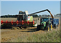
Harvesting at Barrow Mere
The combine is a Claas Lexion 750.
Image: © David Wright
Taken: 26 Aug 2013
0.12 miles
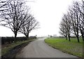
5
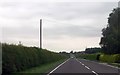
Long straight at Barrow Mere
A1077 towards Barrow
Image: © John Firth
Taken: 10 Jun 2013
0.18 miles
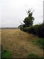
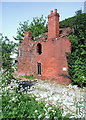
6
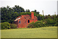
The Ruined House
This ruin, which lies just South of the Barrow Road, is known locally as "The Murder House" see http://www.thisisscunthorpe.co.uk/news/Murder-mystery-runs-40-years/article-896153-detail/article.html
Image: © David Wright
Taken: 11 Jun 2006
0.18 miles
7
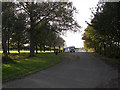
Barrow Road Picnic Area
This area off the Barrow Road (A1077) forms a picnic area and offers a viewpoint for the Humber bridge.
Image: © David Wright
Taken: 3 Nov 2006
0.18 miles
8
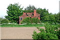
Holly Dene, Barrow Mere
Derelict house on the north side of the A1077 just east of the parish boundary between Barrow and Barton.
Image: © Paul Glazzard
Taken: 12 May 2008
0.19 miles
9
Holly Dene, Barrow Mere
Derelict house on the north side of the A1077 just east of the parish boundary between Barrow and Barton.
Image: © Paul Glazzard
Taken: 12 May 2008
0.19 miles
10

Picnic area on the A1077
Near Barrow Mere, Barrow upon Humber.
Image: © Ian S
Taken: 20 Aug 2010
0.20 miles