IMAGES TAKEN NEAR TO
Barrow Road, BARTON-UPON-HUMBER, DN18 6AA
Introduction
This page details the photographs taken nearby to Barrow Road, DN18 6AA by members of the Geograph project.
The Geograph project started in 2005 with the aim of publishing, organising and preserving representative images for every square kilometre of Great Britain, Ireland and the Isle of Man.

There are currently over 7.5m images from over14,400 individuals and you can help contribute to the project by visiting https://www.geograph.org.uk
Image Map (Loading...)


Getting Data...Please wait
Leaflet Map data © OpenStreetMap
Images are licensed for reuse under creativecommons.org/licenses/by-sa/2.0
Notes
- Clicking on the map will re-center to the selected point.
- The higher the marker number, the further away the image location is from the centre of the postcode.
Image Listing (740 Images Found)
Images are licensed for reuse under creativecommons.org/licenses/by-sa/2.0
Image
Details
Distance
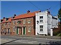
1
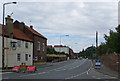
Barrow Road
Photo taken from the corner of Whitecross Street. On the left of the picture is the Blue Bell public house.
Image: © David Wright
Taken: 5 Jul 2007
0.00 miles
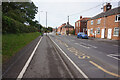
2

Barrow Road
Looking along the A1077 Barrow Road. The runners are taking part in the Humber Bridge half marathon.
Image: © DS Pugh
Taken: 24 Jun 2018
0.01 miles
3
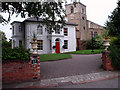
The Old Vicarage
The Old Vicarage, Barton-Upon-Humber. In the background is the church of St. Peter with its Saxon tower, now under the care of English Heritage.
Image: © David Wright
Taken: 29 Jun 2004
0.04 miles
4

St. Peter's Churchyard
Churchyard of St. Peter, Barton-Upon-Humber, North Lincolnshire.
Image: © David Wright
Taken: 11 Dec 2005
0.04 miles
5
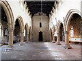
Interior of the Church of St. Peter, Barton-Upon-Humber
St. Peter's is now under the care of English Heritage. Picture taken looking West towards the Saxon tower. See Image for a view of the exterior.
Image: © David Wright
Taken: 9 Jul 2006
0.04 miles
7
Barrow Road, Barton-upon-Humber, Lincolnshire
No.1 Barrow Road, former lodge to the now demolished Whitecross House. Early 19th century house, painted brick. Grade II Listed Building https://www.historicengland.org.uk/listing/the-list/list-entry/1083102
At left, town houses at Nos.9 to 12 Bluebell Court, Whitecross Street, built circa 2011.
Image: © Bernard Sharp
Taken: 10 May 2017
0.05 miles
8
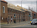
New Housing on Barrow Road
The Blue Bell public house Image] has closed and these houses are being constructed on the site of the former car park.
Image: © David Wright
Taken: 5 Mar 2015
0.06 miles
9
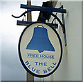
The Sign of the Blue Bell
The Blue Bell is situated on the corner of Barrow Road and Whitecross Street Image
Image: © David Wright
Taken: 16 Mar 2008
0.07 miles
10
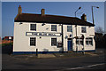
The Blue Bell
Public house on the corner of Whitecross Street and Barrow Road
Image: © Richard Croft
Taken: 8 Mar 2011
0.07 miles