IMAGES TAKEN NEAR TO
Pilots View, BARTON-UPON-HUMBER, DN18 5TS
Introduction
This page details the photographs taken nearby to Pilots View, DN18 5TS by members of the Geograph project.
The Geograph project started in 2005 with the aim of publishing, organising and preserving representative images for every square kilometre of Great Britain, Ireland and the Isle of Man.

There are currently over 7.5m images from over14,400 individuals and you can help contribute to the project by visiting https://www.geograph.org.uk
Image Map (Loading...)


Getting Data...Please wait
Leaflet Map data © OpenStreetMap
Images are licensed for reuse under creativecommons.org/licenses/by-sa/2.0
Notes
- Clicking on the map will re-center to the selected point.
- The higher the marker number, the further away the image location is from the centre of the postcode.
Image Listing (498 Images Found)
Images are licensed for reuse under creativecommons.org/licenses/by-sa/2.0
Image
Details
Distance
4
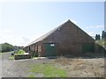
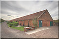
Hall's Barton Ropery
Photo shows the track used in the manufacture of large hawsers. I believe the number "240" on the wall to the right shows the length in fathoms. It looks as though a maximum of 250 fathoms could be manufactured but the end of the track is now lost. Hall's Barton Ropery opened in 1767 and closed in 1989.
Image: © David Wright
Taken: 24 Apr 2007
0.03 miles
5
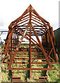
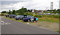
Strange Structure
Seen in the grounds of a small shipyard at Barton. Superficially, it looks like an inverted boat frame... but I'm not sure really what it's for!
Image: © Andy Beecroft
Taken: 25 Mar 2009
0.04 miles
6
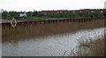
Barton Haven at High Tide - 7.3m
Photo taken from the Waterside Road end of the footbridge over Barton Haven. The distant housing is a recent development off Maltkiln Lane which is below high tide level and relies on the foreground flood defences for protection.
Image: © David Wright
Taken: 16 Apr 2007
0.04 miles
8
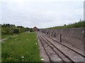
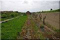
Rail tracks north of The Ropeworks
I assume these were used to drag the ropes out of the ropeworks
Image: © John Firth
Taken: 10 Jun 2013
0.04 miles
9
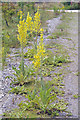
Great Mullein
Great Mullein growing in Waters' Edge Car Park. For information on this plant see Wikipedia article http://en.wikipedia.org/wiki/Verbascum_thapsus .
Image: © David Wright
Taken: 10 Jul 2007
0.04 miles
10
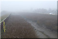
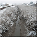
Barton Haven shrouded in December Fog
Image: © David Wright
Taken: 19 Dec 2006
0.04 miles