IMAGES TAKEN NEAR TO
Maltby Lane, BARTON-UPON-HUMBER, DN18 5PY
Introduction
This page details the photographs taken nearby to Maltby Lane, DN18 5PY by members of the Geograph project.
The Geograph project started in 2005 with the aim of publishing, organising and preserving representative images for every square kilometre of Great Britain, Ireland and the Isle of Man.

There are currently over 7.5m images from over14,400 individuals and you can help contribute to the project by visiting https://www.geograph.org.uk
Image Map (Loading...)


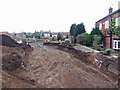
Getting Data...Please wait
Leaflet Map data © OpenStreetMap
Images are licensed for reuse under creativecommons.org/licenses/by-sa/2.0
Notes
- Clicking on the map will re-center to the selected point.
- The higher the marker number, the further away the image location is from the centre of the postcode.
Image Listing (769 Images Found)
Images are licensed for reuse under creativecommons.org/licenses/by-sa/2.0
Image
Details
Distance
2
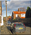
Maltby Lane, Barton-upon-Humber, Lincolnshire
Maltby Cottage, Maltby Lane, early-mid 19th century.
Image: © Bernard Sharp
Taken: 10 May 2017
0.02 miles
3
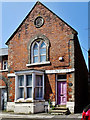
Maltby Lane, Barton-upon-Humber, Lincolnshire
School House, No.1A Maltby Lane, former schoolhouse to the adjoining former Wesleyan Day School, opened 1867, closed 1915.
Image: © Bernard Sharp
Taken: 10 May 2017
0.02 miles
4
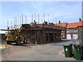
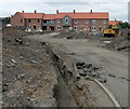
Urban Infill Site, Maltby Lane, Barton Upon Humber
This site must be typical of many across England. The developer has purchased the garden of the house on the right and thus gained access to an otherwise "landlocked" plot of land enabling the building of twelve houses. The relevant planning policies are:
"Policy H3 (Previously Used Land) applies which states that the development of previously used land will be preferred in sequence to the take-up of greenfield sites in the locality."
"Policy H9 (Housing Density) requires a density of at least 37.5 dwellings per ha within the town centres of principal growth settlements such as
Barton."
Image: © David Wright
Taken: 16 Dec 2007
0.02 miles
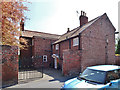
5
HUB - Maltby Lane
The Development Trust Association http://www.dta.org.uk/ has transformed the former North Lincolnshire Council Youth Centre into a community assets hub "Community Assets is funded by the Office of the Third Sector and managed by the Big Lottery Fund. The aim of the £30m programme is community empowerment facilitated by the transfer of genuine assets from local authorities to the third sector for community benefit."
Image: © David Wright
Taken: 30 Jun 2010
0.02 miles
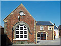
6

Former Wesleyan Day School - Maltby Lane
Operated as a day school between 1867 and 1915.
Image: © Betty Longbottom
Taken: 11 Sep 2009
0.03 miles
7
Residential Development off Maltby Lane
Work started on this residential development towards the end of 2007 Image] but halted during the credit crunch. Activity on the site has now restarted.
Image: © David Wright
Taken: 2 Apr 2010
0.03 miles
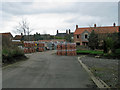
8
New Housing Development off Maltby Lane
This development went into hibernation during the credit crunch but is now slowly proceeding.
Image: © David Wright
Taken: 4 Jul 2010
0.03 miles
9
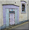
Fire Exit Door of the old Oxford Cinema, Maltby Lane
The old Oxford Cinema on Newport Street has been converted to Squash courts but the old fire exit to Maltby Lane remains.
Image: © David Wright
Taken: 16 Dec 2007
0.03 miles