IMAGES TAKEN NEAR TO
Victoria Drive, BARTON-UPON-HUMBER, DN18 5AY
Introduction
This page details the photographs taken nearby to Victoria Drive, DN18 5AY by members of the Geograph project.
The Geograph project started in 2005 with the aim of publishing, organising and preserving representative images for every square kilometre of Great Britain, Ireland and the Isle of Man.

There are currently over 7.5m images from over14,400 individuals and you can help contribute to the project by visiting https://www.geograph.org.uk
Image Map (Loading...)


Getting Data...Please wait
Leaflet Map data © OpenStreetMap
Images are licensed for reuse under creativecommons.org/licenses/by-sa/2.0
Notes
- Clicking on the map will re-center to the selected point.
- The higher the marker number, the further away the image location is from the centre of the postcode.
Image Listing (308 Images Found)
Images are licensed for reuse under creativecommons.org/licenses/by-sa/2.0
Image
Details
Distance
3
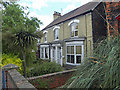
Cyprus Villas, Dam Road, Barton Upon Humber
Victorian houses in yellow brick.
Image: © David Wright
Taken: 4 Jul 2009
0.06 miles
4
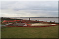
William Blyth Tileworks on the Humber Bank: 2014
There have been various developments over the last few years, as depicted in several pictures in this square.
The site is a restored, fully operational tile works and is one of the last tile factories in Europe of its kind.
The original tile works was established in 1840 and was one of 15 tile factories along the River Humber.
It has operated as a family business for 173 years and continues to produce hand-crafted traditional roof tiles, pantiles and other variations.
There are also other artisan workshops.
The site was closed when I visited, following the tidal surge of December 2013.
Image: © Chris
Taken: 26 Feb 2014
0.06 miles
5
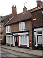
Former Post Office, 75 Fleetgate, Barton Upon Humber
Grade II listed building. The listing is as follows:
"1.5264 FLEETGATE
(West Side)
Fleetgate Post Office
TA 0222 2/17
II GV
2.C18. 2 storeys in brick with steep pantile roof with 2 brick stacks and diagonal-set brick eaves cornice. 2 canted windows to 1st floor. Ground floor has shop front with plain pilasters and half-glazed door. Passage door to left. Shop front to right has pilasters, entablature and modillion cornice, large glazing bars."
Listing NGR: TA0285222402
Image: © David Wright
Taken: 9 Jun 2010
0.07 miles
6
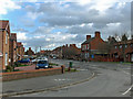
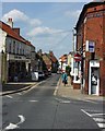
Dam Road, Barton Upon Humber
Photo taken from the corner of Humber Road.
Image: © David Wright
Taken: 5 Feb 2008
0.07 miles
7
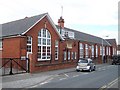
Castle Dykes School
Primary school built in 1914.
Image: © Chris Jagger
Taken: 6 May 2007
0.07 miles
8
National Grid Location C16, Dam Road
The first Barton Gasworks opened on this site in 1846 and Dam Road was previously known as Gas House Lane.
Image: © David Wright
Taken: 2 Jan 2009
0.07 miles
9
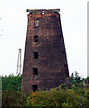
The Old Mill
Old Mill near Barton Station.
Image: © David Wright
Taken: 12 Sep 2006
0.08 miles
10
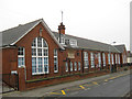
Castledyke Primary School, Barton Upon Humber
This school is situated on Castledyke West. The date stone reads "Lindsey County Council, Castle Dykes School, A1914D." For a photo of the inscription and school bell see Image
Image: © David Wright
Taken: 31 Dec 2008
0.08 miles