IMAGES TAKEN NEAR TO
High Street, SCUNTHORPE, DN17 4PA
Introduction
This page details the photographs taken nearby to High Street, DN17 4PA by members of the Geograph project.
The Geograph project started in 2005 with the aim of publishing, organising and preserving representative images for every square kilometre of Great Britain, Ireland and the Isle of Man.

There are currently over 7.5m images from over14,400 individuals and you can help contribute to the project by visiting https://www.geograph.org.uk
Image Map
Images are licensed for reuse under creativecommons.org/licenses/by-sa/2.0
Notes
- Clicking on the map will re-center to the selected point.
- The higher the marker number, the further away the image location is from the centre of the postcode.
Image Listing (65 Images Found)
Images are licensed for reuse under creativecommons.org/licenses/by-sa/2.0
Image
Details
Distance
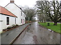
1
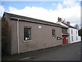
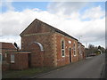
Eastoft Village Hall
Built over an old course of the River Don.
Image: © Jonathan Thacker
Taken: 11 Mar 2011
0.02 miles
2
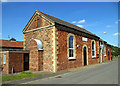
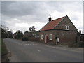
Eastoft Methodist Church
Eastoft Methodist Church & School, High Street. The facade carries a date of 1869.
Image: © David Wright
Taken: 9 Sep 2006
0.03 miles
3
Eastoft Post Office
Eastoft Post Office, High Street.
Image: © David Wright
Taken: 9 Sep 2006
0.03 miles
4
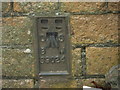
Ordnance Survey Flush Bracket S9024
This bracket can be found on the wall of a former Methodist Church in Eastoft. The benchmark's recorded height is 3.778 metres above sea level.
For more detail see : https://www.bench-marks.org.uk/bm1798
Image: © Peter Wood
Taken: 20 Dec 2019
0.04 miles
5
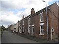
Houses in Eastoft
Nothing special but some have nice doorways.
Image: © Jonathan Thacker
Taken: 11 Mar 2011
0.04 miles
6
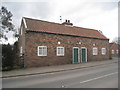
Eastoft Methodist Church
As it has developed this church has been progressively extended along its narrow site between two roads.
Image: © Jonathan Thacker
Taken: 11 Mar 2011
0.05 miles
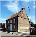
7
Cottage in Eastoft
A tiny dwelling recently re-roofed. Built close to the roadside and with quite fanciful brickwork in the gable-ends.
Image: © Jonathan Thacker
Taken: 11 Mar 2011
0.05 miles
8
Pair of cottages in Eastoft
A very basic type of housing.
Image: © Jonathan Thacker
Taken: 11 Mar 2011
0.06 miles
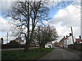
9
High Street in Eastoft
Looking south-westward. The road on the right of the picture is the A161 which results in High Street being virtually traffic free.
Image: © Peter Wood
Taken: 20 Dec 2019
0.08 miles
10
An old course of the River Don
The grassed area is an old course of the River Don which divided Eastoft into two parishes - one, on the left, in the West Riding of Yorkshire and the other, on the right, in the Parts of Lindsey, Lincolnshire. With the creation of Humberside in 1974 the two were united. Since 1996 Eastoft has been part of North Lincolnshire.
Image: © Jonathan Thacker
Taken: 11 Mar 2011
0.09 miles