IMAGES TAKEN NEAR TO
Wyvern Close, SCUNTHORPE, DN17 4NW
Introduction
This page details the photographs taken nearby to Wyvern Close, DN17 4NW by members of the Geograph project.
The Geograph project started in 2005 with the aim of publishing, organising and preserving representative images for every square kilometre of Great Britain, Ireland and the Isle of Man.

There are currently over 7.5m images from over14,400 individuals and you can help contribute to the project by visiting https://www.geograph.org.uk
Image Map (Loading...)


Getting Data...Please wait
Leaflet Map data © OpenStreetMap
Images are licensed for reuse under creativecommons.org/licenses/by-sa/2.0
Notes
- Clicking on the map will re-center to the selected point.
- The higher the marker number, the further away the image location is from the centre of the postcode.
Image Listing (26 Images Found)
Images are licensed for reuse under creativecommons.org/licenses/by-sa/2.0
Image
Details
Distance
1
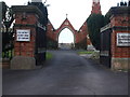
Crowle Cemetery
As seen from underneath the arch of the cemetery chapel and administration building.
Image: © David Squire
Taken: 4 May 2006
0.06 miles
2

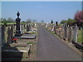
Crowle Cemetery
What looks as though it might have been a chapel on the left of the arch is, in fact, only used for storing maintenance equipment. The cemetery itself is a long and thin plot with the main access from one lane straight down the middle - as can be glimpsed in this photograph.
Image: © David Squire
Taken: 4 May 2006
0.06 miles

5

Dilapidated house by Mill Road, Crowle
Image: © Neil Theasby
Taken: 18 Aug 2021
0.09 miles

7
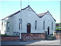
Crowle Baptist Church
Located at the junction of Fieldside and Mill Hill
Image: © Angus Townley
Taken: 3 Jul 2005
0.13 miles
8

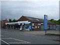
Crowle garage
This is the only garage in Crowle and has only one fuel pump.
Image: © Mike Kirby
Taken: 13 Jul 2008
0.17 miles
9

Site of Crowle (Isle of Axholme Light Railway) station
View northward, towards Goole: former Isle of Axholme Light Railway (NE & L&Y Joint), which ran from Goole to Fockerby and to Haxey, Crowle being on the Haxey line. The line lost its passenger service from 15/7/33, but goods continued until 5/4/65. There was little trace here in 1983.
Image: © Ben Brooksbank
Taken: 26 Aug 1983
0.19 miles