IMAGES TAKEN NEAR TO
Oades Close, SCUNTHORPE, DN17 4FG
Introduction
This page details the photographs taken nearby to Oades Close, DN17 4FG by members of the Geograph project.
The Geograph project started in 2005 with the aim of publishing, organising and preserving representative images for every square kilometre of Great Britain, Ireland and the Isle of Man.

There are currently over 7.5m images from over14,400 individuals and you can help contribute to the project by visiting https://www.geograph.org.uk
Image Map (Loading...)


Getting Data...Please wait
Leaflet Map data © OpenStreetMap
Images are licensed for reuse under creativecommons.org/licenses/by-sa/2.0
Notes
- Clicking on the map will re-center to the selected point.
- The higher the marker number, the further away the image location is from the centre of the postcode.
Image Listing (154 Images Found)
Images are licensed for reuse under creativecommons.org/licenses/by-sa/2.0
Image
Details
Distance
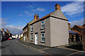
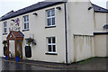
3
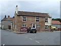
The Red Lion, Crowle
This is looking north along North Street.
Image: © Peter Church
Taken: 13 Jan 2009
0.05 miles
4
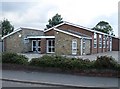
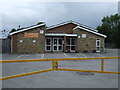
Crowle Community Centre
Located on Woodland Avenue at the northern end of the village
Image: © Mike Kirby
Taken: 10 Aug 2008
0.05 miles
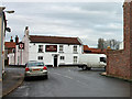
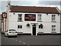
6
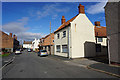
The Red Lion, Crowle
Traditional pub on North Street; the public bar here is called the Mancave.
Image: © Stephen McKay
Taken: 20 Dec 2019
0.05 miles
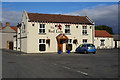
7
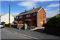
The Red Lion
A more traditional pub with a large beer garden and children's play area.
Image: © Mike Kirby
Taken: 10 Aug 2008
0.06 miles