IMAGES TAKEN NEAR TO
Windsor Court, Windsor Road, SCUNTHORPE, DN17 4FB
Introduction
This page details the photographs taken nearby to Windsor Court, Windsor Road, DN17 4FB by members of the Geograph project.
The Geograph project started in 2005 with the aim of publishing, organising and preserving representative images for every square kilometre of Great Britain, Ireland and the Isle of Man.

There are currently over 7.5m images from over14,400 individuals and you can help contribute to the project by visiting https://www.geograph.org.uk
Image Map (Loading...)


Getting Data...Please wait
Leaflet Map data © OpenStreetMap
Images are licensed for reuse under creativecommons.org/licenses/by-sa/2.0
Notes
- Clicking on the map will re-center to the selected point.
- The higher the marker number, the further away the image location is from the centre of the postcode.
Image Listing (135 Images Found)
Images are licensed for reuse under creativecommons.org/licenses/by-sa/2.0
Image
Details
Distance
1
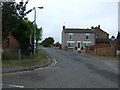
Marsh Road, Crowle
Heading south west to become a bridleway.
Image: © JThomas
Taken: 28 Jun 2014
0.01 miles
2
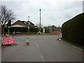
Temporary traffic lights on Commonside, Crowle
Image: © Ian S
Taken: 2 Apr 2011
0.04 miles
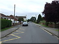
6
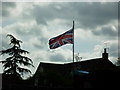
Upside down Union Flags #16
On Cross street, Crowle
Image: © Ian S
Taken: 21 May 2011
0.08 miles
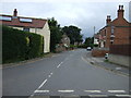
8
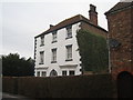
House in Cross Street, Crowle
One of Crowle's grander houses.
Image: © Jonathan Thacker
Taken: 26 Dec 2010
0.12 miles
10

Interior of St Oswald, Crowle
The Runic stone.
Image: © Dave Hitchborne
Taken: 23 Jul 2004
0.13 miles