IMAGES TAKEN NEAR TO
Russell Walk, SCUNTHORPE, DN17 3TU
Introduction
This page details the photographs taken nearby to Russell Walk, DN17 3TU by members of the Geograph project.
The Geograph project started in 2005 with the aim of publishing, organising and preserving representative images for every square kilometre of Great Britain, Ireland and the Isle of Man.

There are currently over 7.5m images from over14,400 individuals and you can help contribute to the project by visiting https://www.geograph.org.uk
Image Map
Images are licensed for reuse under creativecommons.org/licenses/by-sa/2.0
Notes
- Clicking on the map will re-center to the selected point.
- The higher the marker number, the further away the image location is from the centre of the postcode.
Image Listing (12 Images Found)
Images are licensed for reuse under creativecommons.org/licenses/by-sa/2.0
Image
Details
Distance
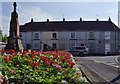
3
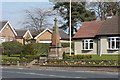
The War Memorial at Messingham
Taken while walking the Opencast Way.
Image: © Ian S
Taken: 21 Mar 2016
0.21 miles
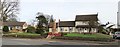
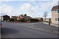
4
War memorial and New Row, Messingham
Seen from the A159 High Street.
Image: © Paul Harrop
Taken: 19 Sep 2008
0.22 miles
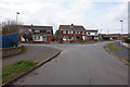
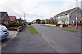
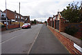
6
Wendover Road at Wendover Close, Messingham
Taken while walking the Opencast Way.
Image: © Ian S
Taken: 21 Mar 2016
0.23 miles
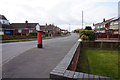
9
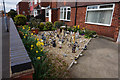
Garden on Danby Road, Messingham
Taken while walking the Opencast Way.
Image: © Ian S
Taken: 21 Mar 2016
0.23 miles