IMAGES TAKEN NEAR TO
Northfield Road, SCUNTHORPE, DN17 3SH
Introduction
This page details the photographs taken nearby to Northfield Road, DN17 3SH by members of the Geograph project.
The Geograph project started in 2005 with the aim of publishing, organising and preserving representative images for every square kilometre of Great Britain, Ireland and the Isle of Man.

There are currently over 7.5m images from over14,400 individuals and you can help contribute to the project by visiting https://www.geograph.org.uk
Image Map (Loading...)


Getting Data...Please wait
Leaflet Map data © OpenStreetMap
Images are licensed for reuse under creativecommons.org/licenses/by-sa/2.0
Notes
- Clicking on the map will re-center to the selected point.
- The higher the marker number, the further away the image location is from the centre of the postcode.
Image Listing (7 Images Found)
Images are licensed for reuse under creativecommons.org/licenses/by-sa/2.0
Image
Details
Distance

2
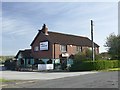
The Bird in the Barley
Public house and restaurant on Northfield Road
Image: © Graham Hogg
Taken: 23 Oct 2018
0.11 miles
3
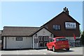
Bird in Barley Pub
Near Messingham.
Image: © J.Hannan-Briggs
Taken: 27 May 2012
0.11 miles
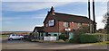
6
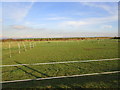
Paddocks behind the Bird in the Barley
Image: © Jonathan Thacker
Taken: 4 Nov 2014
0.16 miles
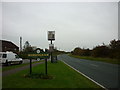
7
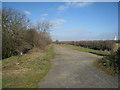
Former route of the A159
The road was diverted when the M180 was constructed.
Image: © Jonathan Thacker
Taken: 7 Mar 2011
0.22 miles