IMAGES TAKEN NEAR TO
Ash Grove, SCUNTHORPE, DN17 3QY
Introduction
This page details the photographs taken nearby to Ash Grove, DN17 3QY by members of the Geograph project.
The Geograph project started in 2005 with the aim of publishing, organising and preserving representative images for every square kilometre of Great Britain, Ireland and the Isle of Man.

There are currently over 7.5m images from over14,400 individuals and you can help contribute to the project by visiting https://www.geograph.org.uk
Image Map
Images are licensed for reuse under creativecommons.org/licenses/by-sa/2.0
Notes
- Clicking on the map will re-center to the selected point.
- The higher the marker number, the further away the image location is from the centre of the postcode.
Image Listing (14 Images Found)
Images are licensed for reuse under creativecommons.org/licenses/by-sa/2.0
Image
Details
Distance
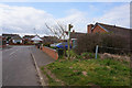
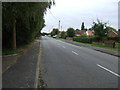
2
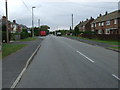
Brigg Road, Messingham
Heading south east towards Kirton in Lindsey.
Image: © JThomas
Taken: 20 Sep 2014
0.09 miles
5
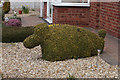
Dog shaped topiary on Kealholme Road, Messingham
Taken while walking the Opencast Way. http://www.geograph.org.uk/photo/4880164
Image: © Ian S
Taken: 21 Mar 2016
0.19 miles
6
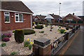
Dog shaped topiary on Kealholme Road, Messingham
Taken while walking the Opencast Way. http://www.geograph.org.uk/photo/4880161
Image: © Ian S
Taken: 21 Mar 2016
0.19 miles
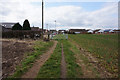
8
Brigg Road, Messingham (B1400)
Heading south east towards Kirton in Lindsey.
Image: © JThomas
Taken: 20 Sep 2014
0.20 miles