IMAGES TAKEN NEAR TO
Derrythorpe Road, SCUNTHORPE, DN17 3JA
Introduction
This page details the photographs taken nearby to Derrythorpe Road, DN17 3JA by members of the Geograph project.
The Geograph project started in 2005 with the aim of publishing, organising and preserving representative images for every square kilometre of Great Britain, Ireland and the Isle of Man.

There are currently over 7.5m images from over14,400 individuals and you can help contribute to the project by visiting https://www.geograph.org.uk
Image Map (Loading...)


Getting Data...Please wait
Leaflet Map data © OpenStreetMap
Images are licensed for reuse under creativecommons.org/licenses/by-sa/2.0
Notes
- Clicking on the map will re-center to the selected point.
- The higher the marker number, the further away the image location is from the centre of the postcode.
Image Listing (42 Images Found)
Images are licensed for reuse under creativecommons.org/licenses/by-sa/2.0
Image
Details
Distance

2
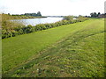
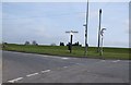
Evening sunlight in Althorpe
This is looking south along the River Trent flood bank towards the southern edge of Althorpe.
Image: © Marathon
Taken: 8 Sep 2019
0.09 miles
3
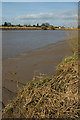
River Trent at Derrythorpe Isle of Axholme North Lincolnshire
View looking North from the bank of the River Trent at Derrythorpe. Village of Althorpe seen in the distance.
Taken at low tide.
Image: © Bob Pearce
Taken: 9 Dec 2017
0.10 miles
4
River Trent, Burringham
Looking north across the bend in the river to the south of the village
Image: © Paul Harrop
Taken: 12 Mar 2009
0.13 miles
5
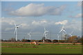
Fields at Derrythorpe
With the Keadby Wind Farm beyond
Image: © Graham Hogg
Taken: 8 Dec 2015
0.14 miles
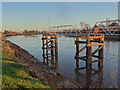
7
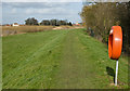
Trent bank, Burringham
The flood embankment on the eastern bank of the Trent. The church in the distance is St Oswald's at Althorpe on the opposite side of the river. The lifebuoy container is, of course, empty. St John the Baptist's Church is to the immediate right of the picture.
Image: © Paul Harrop
Taken: 12 Mar 2009
0.16 miles
8
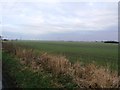
Fields near Derrythorpe
Pictured from the south east corner of the grid square.
Image: © Jonathan Clitheroe
Taken: 13 Feb 2016
0.16 miles
9
River embankment at Althorpe
Part of the Trent Valley Way.
Image: © Colin Park
Taken: 26 Aug 2021
0.16 miles
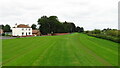
10
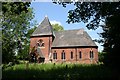
St.John the Baptist's church, Burringham
By S.S.Teulon in 1857
Image: © Richard Croft
Taken: 5 Jun 2006
0.16 miles