IMAGES TAKEN NEAR TO
Poplar Crescent, SCUNTHORPE, DN17 3HB
Introduction
This page details the photographs taken nearby to Poplar Crescent, DN17 3HB by members of the Geograph project.
The Geograph project started in 2005 with the aim of publishing, organising and preserving representative images for every square kilometre of Great Britain, Ireland and the Isle of Man.

There are currently over 7.5m images from over14,400 individuals and you can help contribute to the project by visiting https://www.geograph.org.uk
Image Map
Images are licensed for reuse under creativecommons.org/licenses/by-sa/2.0
Notes
- Clicking on the map will re-center to the selected point.
- The higher the marker number, the further away the image location is from the centre of the postcode.
Image Listing (50 Images Found)
Images are licensed for reuse under creativecommons.org/licenses/by-sa/2.0
Image
Details
Distance

3
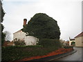
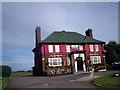
Derelict House in Althorpe
The housing is fast disappearing under a mantle of ivy.
Image: © Jonathan Thacker
Taken: 21 Nov 2010
0.09 miles
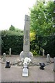
7
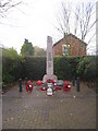
War Memorial, Althorpe
A few days after Remembrance Sunday.
Image: © Jonathan Thacker
Taken: 21 Nov 2010
0.10 miles
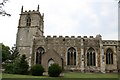
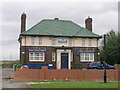
10

Stephenson Memorial Hall
Dated 1903, built at the expense of the Stephenson family who lived at Lansdowne House
Image: © Richard Croft
Taken: 19 Jul 2007
0.10 miles