IMAGES TAKEN NEAR TO
Day Close, SCUNTHORPE, DN17 3DT
Introduction
This page details the photographs taken nearby to Day Close, DN17 3DT by members of the Geograph project.
The Geograph project started in 2005 with the aim of publishing, organising and preserving representative images for every square kilometre of Great Britain, Ireland and the Isle of Man.

There are currently over 7.5m images from over14,400 individuals and you can help contribute to the project by visiting https://www.geograph.org.uk
Image Map
Images are licensed for reuse under creativecommons.org/licenses/by-sa/2.0
Notes
- Clicking on the map will re-center to the selected point.
- The higher the marker number, the further away the image location is from the centre of the postcode.
Image Listing (86 Images Found)
Images are licensed for reuse under creativecommons.org/licenses/by-sa/2.0
Image
Details
Distance
1
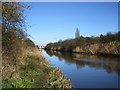
The middle of the Three Rivers
Looking towards the sluice at Keadby. It gets difficult trying to work out which drain is which but I think this is the River Torne.
Image: © Jonathan Thacker
Taken: 9 Mar 2017
0.11 miles
2

"Three Rivers"
Viewed from above the River Trent.
Basically the rivers are the Don, Idle and Torne, though a lot of remodelling took place in order to arrive at this configuration. To understand it you have to study the history of the Isle of Axholme, and of Hatfield Chase and the River Torne. The map of drains in this area resembles the map of the London Underground, but is far more complex.
See: http://en.wikipedia.org/wiki/River_Torne and http://en.wikipedia.org/wiki/Hatfield_Chase :
"Hatfield Chase is a low-lying area in South Yorkshire and North Lincolnshire, England, which was often flooded. It was a royal hunting ground until Charles I appointed the Dutch engineer Cornelius Vermuyden to drain it in 1626. The work involved the re-routing of the Rivers Don, Idle and Torne, and the construction of drainage channels."
Image: © Chris
Taken: 2 Sep 2012
0.11 miles
3
Three Rivers, Keadby
This shows the most southerly of the three rivers at Keadby sluice.
Image: © Jonathan Thacker
Taken: 11 Oct 2012
0.12 miles
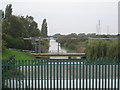
4
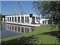
Keadby Sluice Control Building
Image: © Gordon Kneale Brooke
Taken: 31 May 2009
0.12 miles
5
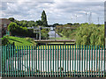
Keadby - south-most of Three Rivers
As seen from sluices on Station Road.
Image: © Dave Bevis
Taken: 30 Aug 2014
0.12 miles
6
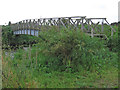
Keadby - footbridge over north-most of Three Rivers
Image: © Dave Bevis
Taken: 30 Aug 2014
0.14 miles
7
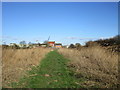
Approaching Keadby
On the north bank of what I think is the Hatfield Waste Drain.
Image: © Jonathan Thacker
Taken: 9 Mar 2017
0.14 miles
8
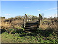
Footbridge over the Hatfield Waste Drain
Image: © Jonathan Thacker
Taken: 9 Mar 2017
0.15 miles
9
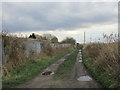
Track alongside the railway
This follows the alignment of the railway prior to its move slightly to the north to access the King George V Bridge over the Trent (opened in 1916).
Image: © Jonathan Thacker
Taken: 12 Mar 2017
0.15 miles
