IMAGES TAKEN NEAR TO
Susworth, SCUNTHORPE, DN17 3AT
Introduction
This page details the photographs taken nearby to DN17 3AT by members of the Geograph project.
The Geograph project started in 2005 with the aim of publishing, organising and preserving representative images for every square kilometre of Great Britain, Ireland and the Isle of Man.

There are currently over 7.5m images from over14,400 individuals and you can help contribute to the project by visiting https://www.geograph.org.uk
Image Map
Images are licensed for reuse under creativecommons.org/licenses/by-sa/2.0
Notes
- Clicking on the map will re-center to the selected point.
- The higher the marker number, the further away the image location is from the centre of the postcode.
Image Listing (5 Images Found)
Images are licensed for reuse under creativecommons.org/licenses/by-sa/2.0
Image
Details
Distance
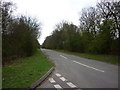
2
Susworth Road
Looking towards Cotes Houses.
Image: © Jonathan Thacker
Taken: 21 Feb 2023
0.06 miles
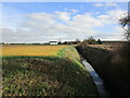
4
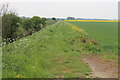
Track along Susworth New Cut Drain
Heading towards South Ings Drain.
Image: © J.Hannan-Briggs
Taken: 4 May 2014
0.13 miles