IMAGES TAKEN NEAR TO
Moorwell Road, SCUNTHORPE, DN17 2TS
Introduction
This page details the photographs taken nearby to Moorwell Road, DN17 2TS by members of the Geograph project.
The Geograph project started in 2005 with the aim of publishing, organising and preserving representative images for every square kilometre of Great Britain, Ireland and the Isle of Man.

There are currently over 7.5m images from over14,400 individuals and you can help contribute to the project by visiting https://www.geograph.org.uk
Image Map (Loading...)


Getting Data...Please wait
Leaflet Map data © OpenStreetMap
Images are licensed for reuse under creativecommons.org/licenses/by-sa/2.0
Notes
- Clicking on the map will re-center to the selected point.
- The higher the marker number, the further away the image location is from the centre of the postcode.
Image Listing (9 Images Found)
Images are licensed for reuse under creativecommons.org/licenses/by-sa/2.0
Image
Details
Distance
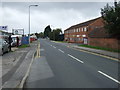
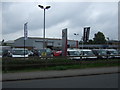
3
Junction of Moorwell Road with Scotter Road South
Looking west.
Image: © JThomas
Taken: 20 Sep 2014
0.09 miles
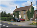
6
Newdown Road, Yaddlethorpe, Scunthorpe
Image: © Steve Fareham
Taken: 3 Jun 2014
0.18 miles

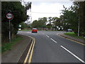
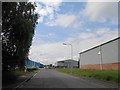
8
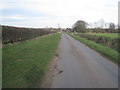
Moor Road
A quiet lane between the edge of town and the motorway.
Image: © Jonathan Thacker
Taken: 14 Mar 2011
0.24 miles
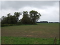
9

Units at South Park Industrial Estate
A management training company and an indoor children's adventure park are two of the businesses here off Hoylake Road.
Image: © Jonathan Billinger
Taken: 27 May 2010
0.25 miles