IMAGES TAKEN NEAR TO
Rosedale, SCUNTHORPE, DN17 2TN
Introduction
This page details the photographs taken nearby to Rosedale, DN17 2TN by members of the Geograph project.
The Geograph project started in 2005 with the aim of publishing, organising and preserving representative images for every square kilometre of Great Britain, Ireland and the Isle of Man.

There are currently over 7.5m images from over14,400 individuals and you can help contribute to the project by visiting https://www.geograph.org.uk
Image Map
Images are licensed for reuse under creativecommons.org/licenses/by-sa/2.0
Notes
- Clicking on the map will re-center to the selected point.
- The higher the marker number, the further away the image location is from the centre of the postcode.
Image Listing (35 Images Found)
Images are licensed for reuse under creativecommons.org/licenses/by-sa/2.0
Image
Details
Distance
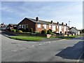
4
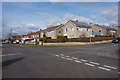
High Street, Yaddlethorpe
A suburban road in South Scunthorpe.
Image: © Jonathan Billinger
Taken: 27 May 2010
0.11 miles
6

Yaddlethorpe Methodist Church
All roof and no walls - on Moorwell Road, Yaddlethorpe
Image: © Richard Croft
Taken: 5 Jun 2006
0.11 miles
7
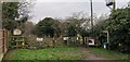
Entry to Southfield Farm
The farm is no longer there and 24 hour access doesn't seem to have been required for some time.
Image: © Chris Morgan
Taken: 5 Feb 2020
0.11 miles
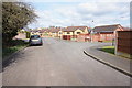
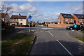
8
Junction of High Street and Endcliffe Avenue
Image: © Graham Hogg
Taken: 23 Oct 2018
0.11 miles
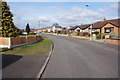
9
Opencast Way towards Croft Lane, Yaddlethorpe
Image: © Ian S
Taken: 21 Mar 2016
0.12 miles
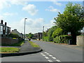
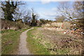
10
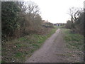
The footpath to Scotter Road South
A typical footpath of the urban fringe.
Image: © Jonathan Thacker
Taken: 19 Mar 2011
0.13 miles