IMAGES TAKEN NEAR TO
Sunningdale Road, SCUNTHORPE, DN17 2TD
Introduction
This page details the photographs taken nearby to Sunningdale Road, DN17 2TD by members of the Geograph project.
The Geograph project started in 2005 with the aim of publishing, organising and preserving representative images for every square kilometre of Great Britain, Ireland and the Isle of Man.

There are currently over 7.5m images from over14,400 individuals and you can help contribute to the project by visiting https://www.geograph.org.uk
Image Map (Loading...)


Getting Data...Please wait
Leaflet Map data © OpenStreetMap
Images are licensed for reuse under creativecommons.org/licenses/by-sa/2.0
Notes
- Clicking on the map will re-center to the selected point.
- The higher the marker number, the further away the image location is from the centre of the postcode.
Image Listing (12 Images Found)
Images are licensed for reuse under creativecommons.org/licenses/by-sa/2.0
Image
Details
Distance
3

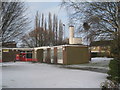
North Lincolnshire Learning Centre
A resource centre for teachers in buildings once occupied by South Park Comprehensive School.
Image: © Jonathan Thacker
Taken: 26 Jan 2013
0.08 miles
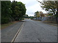
4
Enderby Road Infants School
The chimney adds interest to an otherwise nonedescript building.
Image: © Jonathan Thacker
Taken: 26 Jan 2013
0.09 miles

6
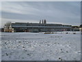
North Lincolnshire Learning Centre (2)
A resource centre for teachers in a building formerly occupied by South Park Comprehensive School. Most of the other buildings of the school have been demolished.
Image: © Jonathan Thacker
Taken: 26 Jan 2013
0.11 miles
7
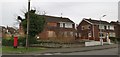
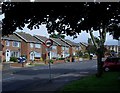
Boarded up house, well maintained garden
Image: © Chris Morgan
Taken: 5 Feb 2020
0.20 miles
9
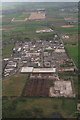
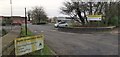
Industrial site south of Silica Country Park
Looking south, with Scotter Road running down the right edge.
Image: © Chris
Taken: 5 May 2013
0.22 miles
10
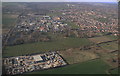
Yaddlethorpe: aerial 2015
Scotter Road on the left.
Image: © Chris
Taken: 5 Apr 2015
0.24 miles