IMAGES TAKEN NEAR TO
Hammerton Road, SCUNTHORPE, DN17 2SA
Introduction
This page details the photographs taken nearby to Hammerton Road, DN17 2SA by members of the Geograph project.
The Geograph project started in 2005 with the aim of publishing, organising and preserving representative images for every square kilometre of Great Britain, Ireland and the Isle of Man.

There are currently over 7.5m images from over14,400 individuals and you can help contribute to the project by visiting https://www.geograph.org.uk
Image Map
Images are licensed for reuse under creativecommons.org/licenses/by-sa/2.0
Notes
- Clicking on the map will re-center to the selected point.
- The higher the marker number, the further away the image location is from the centre of the postcode.
Image Listing (32 Images Found)
Images are licensed for reuse under creativecommons.org/licenses/by-sa/2.0
Image
Details
Distance
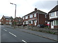
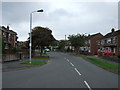
2
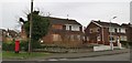
Boarded up house, well maintained garden
Image: © Chris Morgan
Taken: 5 Feb 2020
0.09 miles
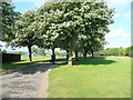
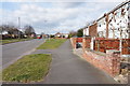
3
Green Corridor, Yaddlethorpe
This wide green space runs approximately north - south through Yaddlethorpe, a suburb of Scunthorpe.
Image: © Peter Church
Taken: 26 Feb 2008
0.09 miles
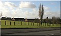
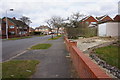
4
Public Park off High Leys Road
Scunthorpe expanded rapidly in the 1950's and 60's as the steel works met the demand for post-war reconstruction.
This was farmland sixty years ago.
Image: © Jonathan Billinger
Taken: 27 May 2010
0.10 miles
5
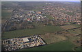
Yaddlethorpe: aerial 2015
Scotter Road on the left.
Image: © Chris
Taken: 5 Apr 2015
0.11 miles
10
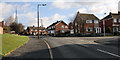
Enderby Road, Yaddlethorpe
Looking uphill, (east) towards the village centre. The spire of the Church of the Holy Spirit is visible above the houses.
Image: © Peter Church
Taken: 26 Feb 2008
0.13 miles