IMAGES TAKEN NEAR TO
High Leys Road, SCUNTHORPE, DN17 2QA
Introduction
This page details the photographs taken nearby to High Leys Road, DN17 2QA by members of the Geograph project.
The Geograph project started in 2005 with the aim of publishing, organising and preserving representative images for every square kilometre of Great Britain, Ireland and the Isle of Man.

There are currently over 7.5m images from over14,400 individuals and you can help contribute to the project by visiting https://www.geograph.org.uk
Image Map
Images are licensed for reuse under creativecommons.org/licenses/by-sa/2.0
Notes
- Clicking on the map will re-center to the selected point.
- The higher the marker number, the further away the image location is from the centre of the postcode.
Image Listing (25 Images Found)
Images are licensed for reuse under creativecommons.org/licenses/by-sa/2.0
Image
Details
Distance
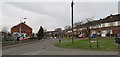
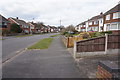
3
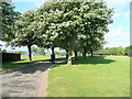
Public Park off High Leys Road
Scunthorpe expanded rapidly in the 1950's and 60's as the steel works met the demand for post-war reconstruction.
This was farmland sixty years ago.
Image: © Jonathan Billinger
Taken: 27 May 2010
0.05 miles
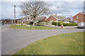
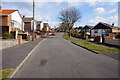
6
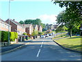
Brankwell Crescent
A quiet residential area of Yaddlethorpe.
Image: © Jonathan Billinger
Taken: 27 May 2010
0.14 miles