IMAGES TAKEN NEAR TO
Aubretia Drive, SCUNTHORPE, DN17 2GA
Introduction
This page details the photographs taken nearby to Aubretia Drive, DN17 2GA by members of the Geograph project.
The Geograph project started in 2005 with the aim of publishing, organising and preserving representative images for every square kilometre of Great Britain, Ireland and the Isle of Man.

There are currently over 7.5m images from over14,400 individuals and you can help contribute to the project by visiting https://www.geograph.org.uk
Image Map (Loading...)


Getting Data...Please wait
Leaflet Map data © OpenStreetMap
Images are licensed for reuse under creativecommons.org/licenses/by-sa/2.0
Notes
- Clicking on the map will re-center to the selected point.
- The higher the marker number, the further away the image location is from the centre of the postcode.
Image Listing (4 Images Found)
Images are licensed for reuse under creativecommons.org/licenses/by-sa/2.0
Image
Details
Distance
2
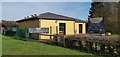
Cafe Natura
Opening soon, by entry to Beckside Linear Park
Image: © Chris Morgan
Taken: 5 Feb 2020
0.07 miles
4
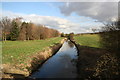
Bottesford Beck
Looking east along Bottesford Beck, years ago it was heavily polluted with outflow from Scunthorpe steelworks, today it flows to the Trent much clearer.
Image: © Richard Croft
Taken: 17 Feb 2006
0.13 miles