IMAGES TAKEN NEAR TO
West Common Lane, SCUNTHORPE, DN17 1DR
Introduction
This page details the photographs taken nearby to West Common Lane, DN17 1DR by members of the Geograph project.
The Geograph project started in 2005 with the aim of publishing, organising and preserving representative images for every square kilometre of Great Britain, Ireland and the Isle of Man.

There are currently over 7.5m images from over14,400 individuals and you can help contribute to the project by visiting https://www.geograph.org.uk
Image Map
Images are licensed for reuse under creativecommons.org/licenses/by-sa/2.0
Notes
- Clicking on the map will re-center to the selected point.
- The higher the marker number, the further away the image location is from the centre of the postcode.
Image Listing (7 Images Found)
Images are licensed for reuse under creativecommons.org/licenses/by-sa/2.0
Image
Details
Distance
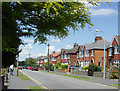
1
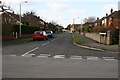
Wynmoor Road
Quite typical of the housing in the area.
Image: © Peter Church
Taken: 26 Feb 2008
0.19 miles
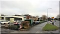
3
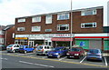
Parade of shops in Old Brumby Street
1960's building beginning to show its age. Flats above have a view across the street of St. Hugh's church, Image
Image: © Jonathan Billinger
Taken: 1 May 2008
0.22 miles
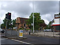
5
Entrance to John Leggott Centre
And West Common Sports Hall
Image: © Chris Morgan
Taken: 23 Jan 2018
0.24 miles
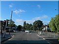
7
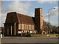
St Hugh's Church, Scunthorpe
Taken from West Common Lane whilst the lights were on red.
Image: © Peter Church
Taken: 26 Feb 2008
0.24 miles