IMAGES TAKEN NEAR TO
Langley Drive, SCUNTHORPE, DN16 3TY
Introduction
This page details the photographs taken nearby to Langley Drive, DN16 3TY by members of the Geograph project.
The Geograph project started in 2005 with the aim of publishing, organising and preserving representative images for every square kilometre of Great Britain, Ireland and the Isle of Man.

There are currently over 7.5m images from over14,400 individuals and you can help contribute to the project by visiting https://www.geograph.org.uk
Image Map
Images are licensed for reuse under creativecommons.org/licenses/by-sa/2.0
Notes
- Clicking on the map will re-center to the selected point.
- The higher the marker number, the further away the image location is from the centre of the postcode.
Image Listing (14 Images Found)
Images are licensed for reuse under creativecommons.org/licenses/by-sa/2.0
Image
Details
Distance
2
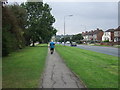
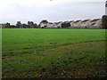
Path beside Mesingham Road (A159)
Looking south.
Image: © JThomas
Taken: 20 Sep 2014
0.08 miles
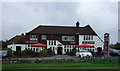
6
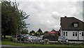
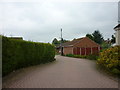
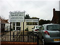
Public House on Moorwell Road, Yaddlethorpe
Image: © Steve Fareham
Taken: 3 Jun 2014
0.15 miles
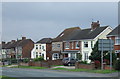
7
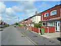
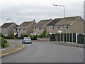
Endcliffe Avenue, Yaddlethorpe
1950's housing in the southern outskirts of Scunthorpe.
Image: © Jonathan Billinger
Taken: 27 May 2010
0.15 miles