IMAGES TAKEN NEAR TO
Timberland, SCUNTHORPE, DN16 3QD
Introduction
This page details the photographs taken nearby to Timberland, DN16 3QD by members of the Geograph project.
The Geograph project started in 2005 with the aim of publishing, organising and preserving representative images for every square kilometre of Great Britain, Ireland and the Isle of Man.

There are currently over 7.5m images from over14,400 individuals and you can help contribute to the project by visiting https://www.geograph.org.uk
Image Map (25 Images)


Getting Data...Please wait
Leaflet Map data © OpenStreetMap
Images are licensed for reuse under creativecommons.org/licenses/by-sa/2.0
Notes
- Clicking on the map will re-center to the selected point.
- The higher the marker number, the further away the image location is from the centre of the postcode.
Image Listing (25 Images Found)
Images are licensed for reuse under creativecommons.org/licenses/by-sa/2.0
Image
Details
Distance
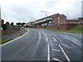
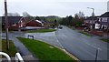
5
Holme Hall Avenue, 2
Looking east from The Beckwood PH car park.
Image: © Jonathan Billinger
Taken: 25 Nov 2018
0.15 miles
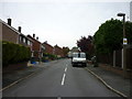
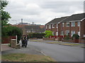
8
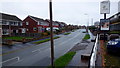
Holme Hall Avenue, 1
Looking away from the village centre towards open countryside, past the turn for Queenswood Road.
Image: © Jonathan Billinger
Taken: 25 Nov 2018
0.18 miles
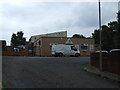
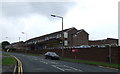
9
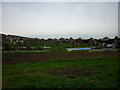
Timberland, Bottesford
Scunthorpe steelworks dominates the skyline.
Image: © Jonathan Thacker
Taken: 13 Jul 2010
0.18 miles