IMAGES TAKEN NEAR TO
Manor Road, SCUNTHORPE, DN16 3PU
Introduction
This page details the photographs taken nearby to Manor Road, DN16 3PU by members of the Geograph project.
The Geograph project started in 2005 with the aim of publishing, organising and preserving representative images for every square kilometre of Great Britain, Ireland and the Isle of Man.

There are currently over 7.5m images from over14,400 individuals and you can help contribute to the project by visiting https://www.geograph.org.uk
Image Map (Loading...)


Getting Data...Please wait
Leaflet Map data © OpenStreetMap
Images are licensed for reuse under creativecommons.org/licenses/by-sa/2.0
Notes
- Clicking on the map will re-center to the selected point.
- The higher the marker number, the further away the image location is from the centre of the postcode.
Image Listing (42 Images Found)
Images are licensed for reuse under creativecommons.org/licenses/by-sa/2.0
Image
Details
Distance
5
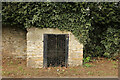
St. John's Well
Grade II listed well head in a 19th century house, but with earlier origins.
Image: © Richard Croft
Taken: 15 Mar 2021
0.09 miles
7
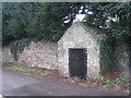
St.John's Well
The former supplier of water to the then village of Bottesford.
Image: © Jonathan Thacker
Taken: 13 Jan 2011
0.10 miles
9
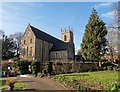
St Peter ad Vincula, Parish Church, Bottesford
Image: © Chris Morgan
Taken: 5 Feb 2020
0.13 miles
10
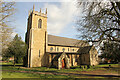
St. Peter ad Vincula
Marvellous Grade I listed church, largely 13th century with tall, slender lancet windows in the chancel and transepts.
Image: © Richard Croft
Taken: 15 Mar 2021
0.13 miles