IMAGES TAKEN NEAR TO
Siskin Crescent, SCUNTHORPE, DN16 3GA
Introduction
This page details the photographs taken nearby to Siskin Crescent, DN16 3GA by members of the Geograph project.
The Geograph project started in 2005 with the aim of publishing, organising and preserving representative images for every square kilometre of Great Britain, Ireland and the Isle of Man.

There are currently over 7.5m images from over14,400 individuals and you can help contribute to the project by visiting https://www.geograph.org.uk
Image Map (Loading...)


Getting Data...Please wait
Leaflet Map data © OpenStreetMap
Images are licensed for reuse under creativecommons.org/licenses/by-sa/2.0
Notes
- Clicking on the map will re-center to the selected point.
- The higher the marker number, the further away the image location is from the centre of the postcode.
Image Listing (38 Images Found)
Images are licensed for reuse under creativecommons.org/licenses/by-sa/2.0
Image
Details
Distance
1
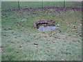
The Templar's Bath, Bottesford (2)
In truth probably nothing to do with the Knights Templar at all. This is a natural spring (which no longer issues water) which has at various times been used for bathing. The water just visible in the picture is the result of recent snow melt and heavy rain.
Image: © Jonathan Thacker
Taken: 13 Jan 2011
0.08 miles
2
The Templar's Bath, Bottesford
In truth probably nothing to do with the Knights Templar at all. This is a natural spring (which no longer issues water) which has at various times been used for bathing. The water just visible in the picture is the result of recent snow melt and heavy rain.
Image: © Jonathan Thacker
Taken: 13 Jan 2011
0.08 miles
3
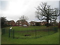
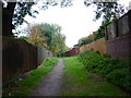
Path from Baldwin Avenue
In Beckside Linear Park
Image: © Chris Morgan
Taken: 5 Feb 2020
0.09 miles
4
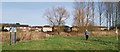
Templar's Bath
Enigmatic spring known as Templar's Bath - a tradition most likely started c1880 by Edward Peacock, an amateur local antiquarian who lived at Bottesford Manor.
Contrary to local belief, there wasn't a Preceptory at Bottesford, but the manor was an endowment for Willoughton Preceptory and there might have been a Grange.
The ancient walnut tree behind was climbed many times by me, over 50 years ago and long before the houses that now surround it.
Image: © Richard Croft
Taken: 15 Mar 2021
0.10 miles
6
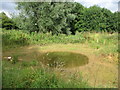
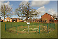
Small pond in Bottesford Beck Linear Park
The park runs from the A159 Messingham Road to the A18 at Emmanuel Bridge and follows the Bottesford Beck.
Image: © Jonathan Thacker
Taken: 11 Aug 2016
0.13 miles
7
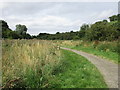
Bottesford Beck Linear Park
The park runs from the A159 Messingham Road to the A18 at Emmanuel Bridge and follows the Bottesford Beck.
Image: © Jonathan Thacker
Taken: 11 Aug 2016
0.15 miles
8
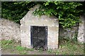
St.John's Well
An ancient well enclosed a Victorian construction in the heart of old Bottesford.
Image: © Richard Croft
Taken: 5 Jun 2006
0.15 miles
10
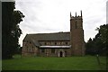
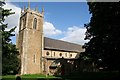
St. Peter's Chains church, Bottesford, Lincs.
St. Peter's is a well kept secret - a perfect Early English cruciform church much as it was in the 13th century. Some wonderful very tall thin lancets in the chancel and transepts give the interior a very holy feeling.
Image: © Richard Croft
Taken: Unknown
0.16 miles