IMAGES TAKEN NEAR TO
Brigg Road, SCUNTHORPE, DN16 1XJ
Introduction
This page details the photographs taken nearby to Brigg Road, DN16 1XJ by members of the Geograph project.
The Geograph project started in 2005 with the aim of publishing, organising and preserving representative images for every square kilometre of Great Britain, Ireland and the Isle of Man.

There are currently over 7.5m images from over14,400 individuals and you can help contribute to the project by visiting https://www.geograph.org.uk
Image Map (Loading...)


Getting Data...Please wait
Leaflet Map data © OpenStreetMap
Images are licensed for reuse under creativecommons.org/licenses/by-sa/2.0
Notes
- Clicking on the map will re-center to the selected point.
- The higher the marker number, the further away the image location is from the centre of the postcode.
Image Listing (28 Images Found)
Images are licensed for reuse under creativecommons.org/licenses/by-sa/2.0
Image
Details
Distance
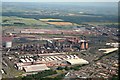
1
Part of the steelworks
Sprawling site to the east of Scunthorpe.
Image: © JThomas
Taken: 20 Sep 2014
0.06 miles
2
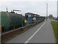
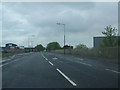
Shared footpath and cycleway Scunthorpe
Image: © Steve Fareham
Taken: 22 Mar 2016
0.07 miles
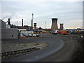
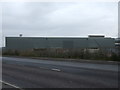
5
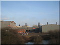
View into the Steelworks
In the background can be seen the four Queens - the blast furnaces named Anne, Victoria, Bess and Mary.
Image: © Jonathan Thacker
Taken: 9 Feb 2011
0.08 miles