IMAGES TAKEN NEAR TO
Redbourne Street, SCUNTHORPE, DN16 1TF
Introduction
This page details the photographs taken nearby to Redbourne Street, DN16 1TF by members of the Geograph project.
The Geograph project started in 2005 with the aim of publishing, organising and preserving representative images for every square kilometre of Great Britain, Ireland and the Isle of Man.

There are currently over 7.5m images from over14,400 individuals and you can help contribute to the project by visiting https://www.geograph.org.uk
Image Map (55 Images)


Leaflet Map data © OpenStreetMap
Images are licensed for reuse under creativecommons.org/licenses/by-sa/2.0
Notes
- Clicking on the map will re-center to the selected point.
- The higher the marker number, the further away the image location is from the centre of the postcode.
Image Listing (55 Images Found)
Images are licensed for reuse under creativecommons.org/licenses/by-sa/2.0
Image
Details
Distance
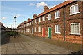
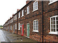
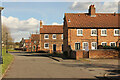
2
Redbourne Street, Frodingham
A street in New Frodingham village. The Scunthorpe Heritage Trail webpage says "This industrial village was built by Rowland Winn around 1870, to provide modern housing for Frodingham iron workers and their families. The original six streets were numbered American-style, each allocated to a particular iron works. Subsequently the streets were named after the ironworks where the residents worked. Winn's village contained all the facilities his workers needed, but his influence as landlord is said to be why it lacked a pub until after his death. The restoration of the village won the Europa Nostra award in 1996 for sympathetic conservation work." See also adjacent Lindsey Street Image
Image: © David Wright
Taken: 23 Oct 2007
0.01 miles
3
Redbourn Street, New Frodingham
Mid 19th century houses in New Frodingham
Image: © Richard Croft
Taken: 15 Mar 2021
0.01 miles
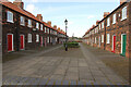
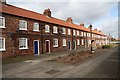
4
Redbourne Street
Housing built by Rowland Winn c1870 for Frodingham iron workers and their families.
Image: © Richard Croft
Taken: 9 Mar 2009
0.02 miles
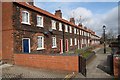
5
Scunthorpe - eastern terrace on Redbourne Street
For an alternative view, please see Image
Image: © Dave Bevis
Taken: 31 Jul 2013
0.04 miles
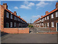
6
Winn Street
One of six streets of housing built by Rowland Winn for ironworkers in the 1870s
Image: © Richard Croft
Taken: 9 Mar 2009
0.04 miles
7
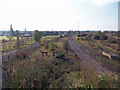
Disused Railway Sidings, Scunthorpe
These sidings are to the East of Scunthorpe station. Photo taken from Brigg Road bridge.
Image: © David Wright
Taken: 23 Oct 2007
0.05 miles
8
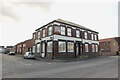
The Queens
Former Queens Hotel http://www.geograph.org.uk/photo/1196949 now converted to flats.
Image: © Richard Croft
Taken: 15 Mar 2021
0.06 miles
10
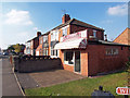
Excel Fisheries, Rowland Road, Scunthorpe
Neighbourhood Chippy on the corner of Rowland Road and Winn Street.
Image: © David Wright
Taken: 23 Oct 2007
0.06 miles