IMAGES TAKEN NEAR TO
Shirley Crescent, SCUNTHORPE, DN16 1NX
Introduction
This page details the photographs taken nearby to Shirley Crescent, DN16 1NX by members of the Geograph project.
The Geograph project started in 2005 with the aim of publishing, organising and preserving representative images for every square kilometre of Great Britain, Ireland and the Isle of Man.

There are currently over 7.5m images from over14,400 individuals and you can help contribute to the project by visiting https://www.geograph.org.uk
Image Map (Loading...)


Getting Data...Please wait
Leaflet Map data © OpenStreetMap
Images are licensed for reuse under creativecommons.org/licenses/by-sa/2.0
Notes
- Clicking on the map will re-center to the selected point.
- The higher the marker number, the further away the image location is from the centre of the postcode.
Image Listing (19 Images Found)
Images are licensed for reuse under creativecommons.org/licenses/by-sa/2.0
Image
Details
Distance
6
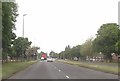
East Common Lane (North Side)
Looking towards the steelworks.
Image: © Jonathan Thacker
Taken: 9 Feb 2011
0.09 miles
7
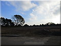
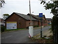
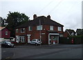
The site of Brumby Hospital
Brumby Hospital went through a variety of uses during its existence but now it has all gone.
Image: © Jonathan Thacker
Taken: 26 Oct 2015
0.12 miles
10
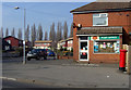
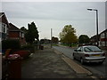
East Common Lane Post Office, Scunthorpe
Small Post Office/shop on the corner of Hampton Road
Image: © Paul Harrop
Taken: 18 Mar 2009
0.19 miles