IMAGES TAKEN NEAR TO
Grange Lane North, SCUNTHORPE, DN16 1DP
Introduction
This page details the photographs taken nearby to Grange Lane North, DN16 1DP by members of the Geograph project.
The Geograph project started in 2005 with the aim of publishing, organising and preserving representative images for every square kilometre of Great Britain, Ireland and the Isle of Man.

There are currently over 7.5m images from over14,400 individuals and you can help contribute to the project by visiting https://www.geograph.org.uk
Image Map
Images are licensed for reuse under creativecommons.org/licenses/by-sa/2.0
Notes
- Clicking on the map will re-center to the selected point.
- The higher the marker number, the further away the image location is from the centre of the postcode.
Image Listing (14 Images Found)
Images are licensed for reuse under creativecommons.org/licenses/by-sa/2.0
Image
Details
Distance
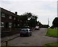
2
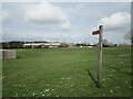
Signpost for the Ironstone Walk
The Ironstone Walk is a 10 mile route through Scunthorpe and Bottesford.
Image: © Jonathan Thacker
Taken: 25 Mar 2021
0.05 miles
3
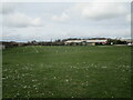
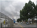
New trees, Grange Lane North
Several hundred new trees have been planted along Grange Lane North.
Image: © Jonathan Thacker
Taken: 25 Mar 2021
0.09 miles
7
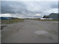
Empty site, East Common Lane
Awaiting an economic upturn.
Image: © Jonathan Thacker
Taken: 27 Jul 2010
0.22 miles
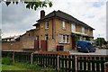
8
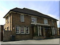
The Open Hearth
A Sam Smith pub in Scunthorpe.
Image: © Ian S
Taken: 22 Jun 2010
0.23 miles
9
The Open Hearth on Warley Road, Scunthorpe
A Sam Smith's public house.
Image: © Ian S
Taken: 11 Jun 2014
0.23 miles
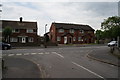
10
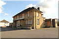
The Open Hearth
Closed pub on Warley Road http://www.geograph.org.uk/photo/1973231 opened in 1954, closed in 2017.
Image: © Richard Croft
Taken: 15 Mar 2021
0.23 miles