IMAGES TAKEN NEAR TO
Ferry Road, SCUNTHORPE, DN15 8LQ
Introduction
This page details the photographs taken nearby to Ferry Road, DN15 8LQ by members of the Geograph project.
The Geograph project started in 2005 with the aim of publishing, organising and preserving representative images for every square kilometre of Great Britain, Ireland and the Isle of Man.

There are currently over 7.5m images from over14,400 individuals and you can help contribute to the project by visiting https://www.geograph.org.uk
Image Map
Images are licensed for reuse under creativecommons.org/licenses/by-sa/2.0
Notes
- Clicking on the map will re-center to the selected point.
- The higher the marker number, the further away the image location is from the centre of the postcode.
Image Listing (63 Images Found)
Images are licensed for reuse under creativecommons.org/licenses/by-sa/2.0
Image
Details
Distance
1
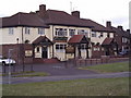
The Cocked Hat
The Cocked Hat hotel on Ferry Road.
Image: © fred roberts
Taken: 20 May 2005
0.01 miles
5
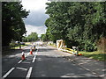
Installing new gas main, Ferry Road
Image: © Jonathan Thacker
Taken: 15 Jul 2010
0.06 miles
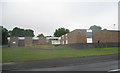
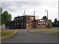
7
Park Community Centre and Library
This end of the building is the Community Centre. The Library is beyond.
Image: © Jonathan Thacker
Taken: 8 Mar 2012
0.06 miles
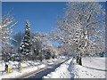
8
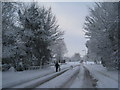
Ferry Road in the snow
More snow than has been seen for many a year.
Image: © Jonathan Thacker
Taken: 1 Dec 2010
0.06 miles
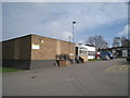
10

Footpath delayed
The heavy snowfall has brought construction of a new footpath from Avenue Vivian to Sherburn Crescent to a halt. This footpath is mainly for the benefit of the increasing number of pupils from Crosby who are going to the primary schools on the Berkeley estate and students from that estate attending ftc (Foxhills Technology College). The footpath which runs from Ferry Road across the Hempdykes to Cliff Closes Road is also being improved.
Image: © Jonathan Thacker
Taken: 3 Dec 2010
0.07 miles