IMAGES TAKEN NEAR TO
Spencer Avenue, SCUNTHORPE, DN15 7SD
Introduction
This page details the photographs taken nearby to Spencer Avenue, DN15 7SD by members of the Geograph project.
The Geograph project started in 2005 with the aim of publishing, organising and preserving representative images for every square kilometre of Great Britain, Ireland and the Isle of Man.

There are currently over 7.5m images from over14,400 individuals and you can help contribute to the project by visiting https://www.geograph.org.uk
Image Map
Images are licensed for reuse under creativecommons.org/licenses/by-sa/2.0
Notes
- Clicking on the map will re-center to the selected point.
- The higher the marker number, the further away the image location is from the centre of the postcode.
Image Listing (69 Images Found)
Images are licensed for reuse under creativecommons.org/licenses/by-sa/2.0
Image
Details
Distance
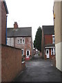
1
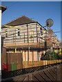
Refurbishing of houses
These houses in Spencer Avenue were built under a plan of Abercrombie in the 1920s and were quite advanced for their time. In recent years they have undergone a considerable amount of refurbishment. At present they appear to be having an exterior insulation applied which is then painted over. Here the painting is completed at first floor level but below the bare insulation material still shows. Note the temporary attaching of the satellite dish to the scaffolding.
Image: © Jonathan Thacker
Taken: 14 May 2012
0.04 miles
2
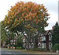
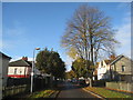
Sycamore Tree, Ferry Road, Scunthorpe
Autumnal hues showing as the leaves of this fine street tree on Ferry Road change colour.
Image: © David Wright
Taken: 12 Oct 2007
0.05 miles
3
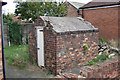
Air Raid Shelter, Ferry Road, Scunthorpe
Rarely seen nowadays an Air Raid Shelter in the rear garden of a house fronting onto Ferry Road. Photo taken from Buckingham Street North.
Image: © David Wright
Taken: 12 Oct 2007
0.06 miles
4
Houses on Ferry Road, Scunthorpe
My eye was caught by the fine Monkey Puzzle tree in the front garden of the left hand of this pair of houses.
Image: © David Wright
Taken: 12 Oct 2007
0.07 miles
5
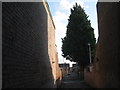
The tenfoot between Dale Street and Buckingham Street
Detuyll Street crosses in the centre of the picture.
Image: © Jonathan Thacker
Taken: 25 Oct 2011
0.09 miles
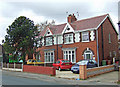
6
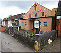
Elim Pentecostal Church, Ferry Road, Scunthorpe
Image: © David Wright
Taken: 12 Oct 2007
0.09 miles
7
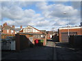
The ten foot behind Ferry Road
Provides access to both residential and commercial properties.
Image: © Jonathan Thacker
Taken: 5 Mar 2012
0.09 miles
8
On Ferry Road
Tahera's Function Hall is the former Elim Pentecostal Church. Adjacent is the Kingdom Hall of the Jehovah's Witnesses.
Image: © Jonathan Thacker
Taken: 3 Nov 2011
0.10 miles
9
Hornsby Crescent in autumn
A mixture of inter-war private and council dwellings.
Image: © Jonathan Thacker
Taken: 29 Oct 2012
0.10 miles
10
The ten foot between Dale Street and Buckingham Street
Always seems to be full of rubbish.
Image: © Jonathan Thacker
Taken: 5 Mar 2012
0.10 miles