
IMAGES TAKEN NEAR TO
Berkeley Street, SCUNTHORPE, DN15 7AQ
Introduction
This page details the photographs taken nearby to Berkeley Street, DN15 7AQ by members of the Geograph project.
The Geograph project started in 2005 with the aim of publishing, organising and preserving representative images for every square kilometre of Great Britain, Ireland and the Isle of Man.

There are currently over 7.5m images from over14,400 individuals and you can help contribute to the project by visiting https://www.geograph.org.uk
Image Map
Images are licensed for reuse under creativecommons.org/licenses/by-sa/2.0
Notes
- Clicking on the map will re-center to the selected point.
- The higher the marker number, the further away the image location is from the centre of the postcode.
Image Listing (128 Images Found)
Images are licensed for reuse under creativecommons.org/licenses/by-sa/2.0
Image
Details
Distance
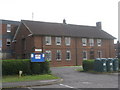
2
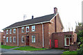
Frodingham Church Hall, Scunthorpe
The church hall is situated on Church Lane, opposite the church of St. Lawrence Image
Image: © David Wright
Taken: 17 Oct 2007
0.02 miles
3
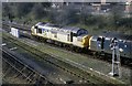
View off the bridge by the station
The view from the road bridge just past Scunthorpe Station as it was twenty years ago with a freight train heading west.
Image: © roger geach
Taken: 17 Mar 1990
0.03 miles
4
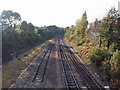
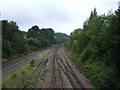
The Railway towards Althorpe
Photo taken from Howden's Hill bridge. The next station going West is Althorpe. This railway cutting between Church Lane and Brumby Wood Lane is known locally as 'The Banks'.
Image: © David Wright
Taken: 23 Oct 2007
0.03 miles
5

Scunthorpe blossoms
In a month when Scunthorpe has been in the national news with the government stepping in to wrest control of the steelworks from it Chinese owners and save the blast furnaces, here in the Frodingham area - oblivious to all of that - a flowering cherry does its thing outside the Royal Mail delivery office on Church Lane.
Image: © Stephen McKay
Taken: 17 Apr 2025
0.04 miles
6
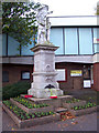
Scunthorpe War Memorial
The Scunthorpe War Memorial is situated on the forecourt of the North Lincolnshire Museum on Oswald Road.
Image: © David Wright
Taken: 4 Nov 2006
0.04 miles
8
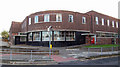
The 1939 Post Office, Oswald Street
The North Lincolnshire Council Town Heritage Walk webpage
describes this building thus "As the town of Scunthorpe grew in the 1930s Patrick Abercrombie, a leading town planner, proposed a new town centre, moving away from the steelworks. In 1939 this elegant art deco-style central post office was built to complement his plans. The crescent shaped façade is matched by that of the Bridge Hotel, built in 1955. Abercrombie went on to produce the 1940s Greater London plan with new towns and a series of ring roads - one of which later became the M25.".
Image: © David Wright
Taken: 17 Oct 2007
0.05 miles
9
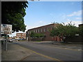
Royal Mail sorting office, Scunthorpe
Image: © Jonathan Thacker
Taken: 21 Jun 2010
0.05 miles
10
St Lawrence's Church information board
Correct at 1st November 2008.
Image: © Mike Kirby
Taken: 1 Nov 2008
0.05 miles