IMAGES TAKEN NEAR TO
Bellasize, GOOLE, DN14 7XS
Introduction
This page details the photographs taken nearby to DN14 7XS by members of the Geograph project.
The Geograph project started in 2005 with the aim of publishing, organising and preserving representative images for every square kilometre of Great Britain, Ireland and the Isle of Man.

There are currently over 7.5m images from over14,400 individuals and you can help contribute to the project by visiting https://www.geograph.org.uk
Image Map
Images are licensed for reuse under creativecommons.org/licenses/by-sa/2.0
Notes
- Clicking on the map will re-center to the selected point.
- The higher the marker number, the further away the image location is from the centre of the postcode.
Image Listing (7 Images Found)
Images are licensed for reuse under creativecommons.org/licenses/by-sa/2.0
Image
Details
Distance
2
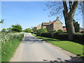
Bellasize Farm on Bellasize Lane near Gilberdyke
Image: © Ian S
Taken: 26 Dec 2010
0.02 miles
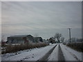
3
Bellasize
This grid square is all farmland. This view looking east.
Image: © Stephen Horncastle
Taken: 28 Jan 2006
0.09 miles
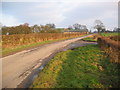
5
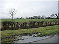
Trees along Bellasize Drain
On the south side of Bellasize Lane, near Lodge Farm.
Image: © Christine Johnstone
Taken: 9 Feb 2018
0.11 miles
6
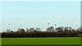
Sixpenny Wood Wind Farm
Viewed across fields from a field path
Image: © Graham Hogg
Taken: 8 Jan 2019
0.15 miles
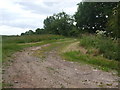
7
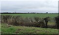
Farmland between Eastfield and Lodge Farms
On the south side of Bellasize Lane. About 3 metres above sea level.
Image: © Christine Johnstone
Taken: 9 Feb 2018
0.18 miles