IMAGES TAKEN NEAR TO
Balkholme, GOOLE, DN14 7XQ
Introduction
This page details the photographs taken nearby to DN14 7XQ by members of the Geograph project.
The Geograph project started in 2005 with the aim of publishing, organising and preserving representative images for every square kilometre of Great Britain, Ireland and the Isle of Man.

There are currently over 7.5m images from over14,400 individuals and you can help contribute to the project by visiting https://www.geograph.org.uk
Image Map
Images are licensed for reuse under creativecommons.org/licenses/by-sa/2.0
Notes
- Clicking on the map will re-center to the selected point.
- The higher the marker number, the further away the image location is from the centre of the postcode.
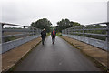
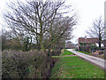
Image Listing (26 Images Found)
Images are licensed for reuse under creativecommons.org/licenses/by-sa/2.0
Image
Details
Distance
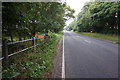

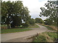
9
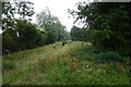
Balkholme
A representative view looking west near the south edge of the grid square. The B1230 and the M62 cross EW through the north of the square.
Image: © Stephen Horncastle
Taken: 11 Feb 2006
0.18 miles
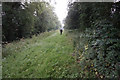
10
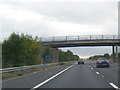
Spenwood Lane
Rudding Lane comes in from the left just before Spenwood Lane bridges the M62.
Image: © Jonathan Thacker
Taken: 10 Oct 2013
0.18 miles