IMAGES TAKEN NEAR TO
Main Street, GOOLE, DN14 7UD
Introduction
This page details the photographs taken nearby to Main Street, DN14 7UD by members of the Geograph project.
The Geograph project started in 2005 with the aim of publishing, organising and preserving representative images for every square kilometre of Great Britain, Ireland and the Isle of Man.

There are currently over 7.5m images from over14,400 individuals and you can help contribute to the project by visiting https://www.geograph.org.uk
Image Map
Images are licensed for reuse under creativecommons.org/licenses/by-sa/2.0
Notes
- Clicking on the map will re-center to the selected point.
- The higher the marker number, the further away the image location is from the centre of the postcode.
Image Listing (45 Images Found)
Images are licensed for reuse under creativecommons.org/licenses/by-sa/2.0
Image
Details
Distance
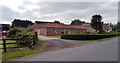
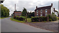
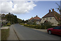
2
Priory Farm, Kilpin
Looking east from Mill Lane, just south of the junction with Narrow Lane in Kilpin village.
Image: © Paul Glazzard
Taken: 19 Jun 2007
0.02 miles
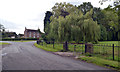

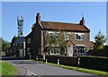
9
Kilpin, north end
At the junction of Mill Lane and Narrow Lane (to the left)
Image: © Paul Harrop
Taken: 4 Oct 2009
0.03 miles
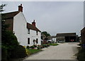
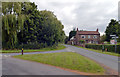
10
Kilpin, south end
Looking along Mill Lane at the southern end of the village
Image: © Paul Harrop
Taken: 4 Oct 2009
0.03 miles