IMAGES TAKEN NEAR TO
Langrick Avenue, GOOLE, DN14 7SS
Introduction
This page details the photographs taken nearby to Langrick Avenue, DN14 7SS by members of the Geograph project.
The Geograph project started in 2005 with the aim of publishing, organising and preserving representative images for every square kilometre of Great Britain, Ireland and the Isle of Man.

There are currently over 7.5m images from over14,400 individuals and you can help contribute to the project by visiting https://www.geograph.org.uk
Image Map (Loading...)


Getting Data...Please wait
Leaflet Map data © OpenStreetMap
Images are licensed for reuse under creativecommons.org/licenses/by-sa/2.0
Notes
- Clicking on the map will re-center to the selected point.
- The higher the marker number, the further away the image location is from the centre of the postcode.
Image Listing (55 Images Found)
Images are licensed for reuse under creativecommons.org/licenses/by-sa/2.0
Image
Details
Distance
1

BLG Renault dealership, Howden
From the petrol station forecourt.
Image: © Steve Fareham
Taken: 6 Apr 2010
0.16 miles


7
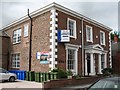
Hailgate House
The front of this house is surprisingly restrained and elegant considering that it was built in 1840. Built as a private residence, but has also been local authority offices and a care home in recent years. Now divided into apartments.
Image: © Gordon Hatton
Taken: 28 May 2009
0.19 miles
9
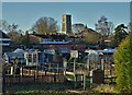
Howden Allotments
With Howden Minster beyond
Image: © Neil Theasby
Taken: 17 Jan 2022
0.20 miles